You are here: Home > Network List > TA - USArray Transportable Network (new EarthScope stations) Stations List
> Station G23K Bananza Creek, AK, USA > Earthquake Result Viewer
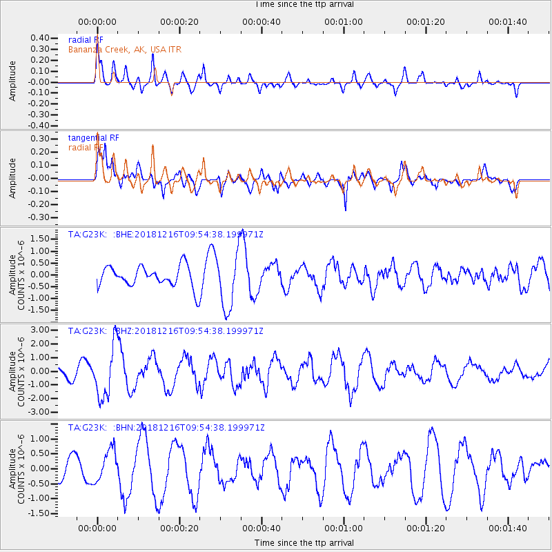
G23K Bananza Creek, AK, USA - Earthquake Result Viewer
*The percent match for this event was below the threshold and hence no stack was calculated.
| Earthquake location: |
Irian Jaya, Indonesia |
| Earthquake latitude/longitude: |
-3.9/140.3 |
| Earthquake time(UTC): |
2018/12/16 (350) 09:42:37 GMT |
| Earthquake Depth: |
61 km |
| Earthquake Magnitude: |
6.1 Mww |
| Earthquake Catalog/Contributor: |
NEIC PDE/us |
|
| Network: |
TA USArray Transportable Network (new EarthScope stations) |
| Station: |
G23K Bananza Creek, AK, USA |
| Lat/Lon: |
66.71 N/150.02 W |
| Elevation: |
746 m |
|
| Distance: |
85.7 deg |
| Az: |
21.962 deg |
| Baz: |
249.79 deg |
| Ray Param: |
$rayparam |
*The percent match for this event was below the threshold and hence was not used in the summary stack. |
|
| Radial Match: |
51.58473 % |
| Radial Bump: |
400 |
| Transverse Match: |
80.40376 % |
| Transverse Bump: |
400 |
| SOD ConfigId: |
13570011 |
| Insert Time: |
2019-05-02 01:42:43.332 +0000 |
| GWidth: |
2.5 |
| Max Bumps: |
400 |
| Tol: |
0.001 |
|
Signal To Noise
| Channel | StoN | STA | LTA |
| TA:G23K: :BHZ:20181216T09:54:38.199971Z | 6.1624956 | 1.977466E-6 | 3.2088718E-7 |
| TA:G23K: :BHN:20181216T09:54:38.199971Z | 1.151405 | 5.447321E-7 | 4.7310203E-7 |
| TA:G23K: :BHE:20181216T09:54:38.199971Z | 2.7853518 | 1.211969E-6 | 4.3512242E-7 |
| Arrivals |
| Ps | |
| PpPs | |
| PsPs/PpSs | |


