You are here: Home > Network List > TJ - Tajikistan National Seismic Network Stations List
> Station GARM Garm, Tajikistan > Earthquake Result Viewer
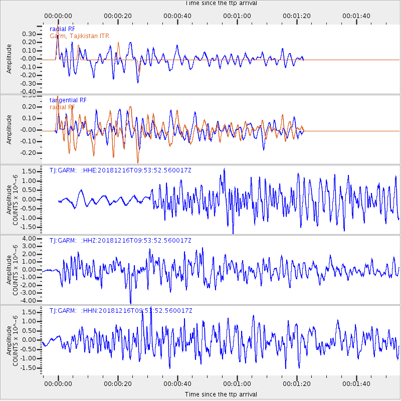
GARM Garm, Tajikistan - Earthquake Result Viewer
*The percent match for this event was below the threshold and hence no stack was calculated.
| Earthquake location: |
Irian Jaya, Indonesia |
| Earthquake latitude/longitude: |
-3.9/140.3 |
| Earthquake time(UTC): |
2018/12/16 (350) 09:42:37 GMT |
| Earthquake Depth: |
61 km |
| Earthquake Magnitude: |
6.1 Mww |
| Earthquake Catalog/Contributor: |
NEIC PDE/us |
|
| Network: |
TJ Tajikistan National Seismic Network |
| Station: |
GARM Garm, Tajikistan |
| Lat/Lon: |
39.00 N/70.32 E |
| Elevation: |
1305 m |
|
| Distance: |
77.1 deg |
| Az: |
311.312 deg |
| Baz: |
105.895 deg |
| Ray Param: |
$rayparam |
*The percent match for this event was below the threshold and hence was not used in the summary stack. |
|
| Radial Match: |
68.87707 % |
| Radial Bump: |
400 |
| Transverse Match: |
72.92281 % |
| Transverse Bump: |
400 |
| SOD ConfigId: |
13570011 |
| Insert Time: |
2019-05-02 01:43:11.932 +0000 |
| GWidth: |
2.5 |
| Max Bumps: |
400 |
| Tol: |
0.001 |
|
Signal To Noise
| Channel | StoN | STA | LTA |
| TJ:GARM: :HHZ:20181216T09:53:52.560017Z | 5.890767 | 9.3951024E-7 | 1.5948861E-7 |
| TJ:GARM: :HHN:20181216T09:53:52.560017Z | 1.5917679 | 2.68009E-7 | 1.683719E-7 |
| TJ:GARM: :HHE:20181216T09:53:52.560017Z | 1.8835502 | 3.592063E-7 | 1.9070706E-7 |
| Arrivals |
| Ps | |
| PpPs | |
| PsPs/PpSs | |


