You are here: Home > Network List > TA - USArray Transportable Network (new EarthScope stations) Stations List
> Station W27A Bowe Ranch, Endee, NM, USA > Earthquake Result Viewer
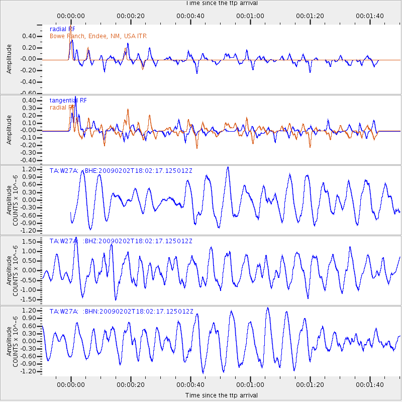
W27A Bowe Ranch, Endee, NM, USA - Earthquake Result Viewer
*The percent match for this event was below the threshold and hence no stack was calculated.
| Earthquake location: |
Near Coast Of Peru |
| Earthquake latitude/longitude: |
-13.6/-76.6 |
| Earthquake time(UTC): |
2009/02/02 (033) 17:53:21 GMT |
| Earthquake Depth: |
21 km |
| Earthquake Magnitude: |
5.6 MB, 5.6 MS, 6.0 MW, 5.9 MW |
| Earthquake Catalog/Contributor: |
WHDF/NEIC |
|
| Network: |
TA USArray Transportable Network (new EarthScope stations) |
| Station: |
W27A Bowe Ranch, Endee, NM, USA |
| Lat/Lon: |
35.06 N/103.06 W |
| Elevation: |
1233 m |
|
| Distance: |
54.5 deg |
| Az: |
333.285 deg |
| Baz: |
147.799 deg |
| Ray Param: |
$rayparam |
*The percent match for this event was below the threshold and hence was not used in the summary stack. |
|
| Radial Match: |
50.614353 % |
| Radial Bump: |
291 |
| Transverse Match: |
64.22089 % |
| Transverse Bump: |
338 |
| SOD ConfigId: |
6627 |
| Insert Time: |
2010-03-06 18:39:12.821 +0000 |
| GWidth: |
2.5 |
| Max Bumps: |
400 |
| Tol: |
0.001 |
|
Signal To Noise
| Channel | StoN | STA | LTA |
| TA:W27A: :BHZ:20090202T18:02:17.125012Z | 2.3725643 | 9.514471E-7 | 4.0102057E-7 |
| TA:W27A: :BHN:20090202T18:02:17.125012Z | 1.0913498 | 4.6353875E-7 | 4.2473894E-7 |
| TA:W27A: :BHE:20090202T18:02:17.125012Z | 0.19160143 | 1.0646565E-7 | 5.556621E-7 |
| Arrivals |
| Ps | |
| PpPs | |
| PsPs/PpSs | |


