You are here: Home > Network List > CB - China National Seismic Network Stations List
> Station CD2 Chengdou,Sichuan Province > Earthquake Result Viewer
CD2 Chengdou,Sichuan Province - Earthquake Result Viewer
| Earthquake location: |
Western Australia |
| Earthquake latitude/longitude: |
-23.3/112.5 |
| Earthquake time(UTC): |
2018/12/16 (350) 14:26:19 GMT |
| Earthquake Depth: |
10 km |
| Earthquake Magnitude: |
5.8 Mww |
| Earthquake Catalog/Contributor: |
NEIC PDE/us |
|
| Network: |
CB China National Seismic Network |
| Station: |
CD2 Chengdou,Sichuan Province |
| Lat/Lon: |
30.91 N/103.76 E |
| Elevation: |
653 m |
|
| Distance: |
54.6 deg |
| Az: |
350.791 deg |
| Baz: |
170.144 deg |
| Ray Param: |
0.065363154 |
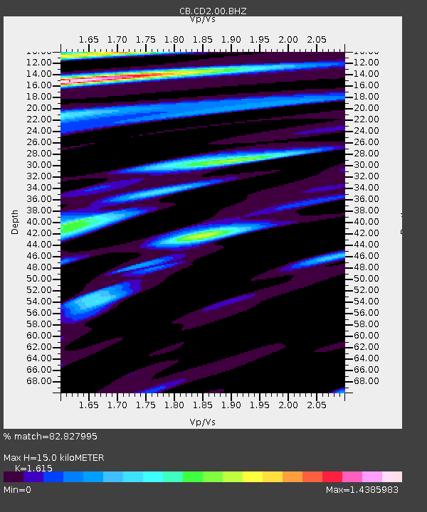
| Estimated Moho Depth: |
15.0 km |
| Estimated Crust Vp/Vs: |
1.62 |
| Assumed Crust Vp: |
6.159 km/s |
| Estimated Crust Vs: |
3.813 km/s |
| Estimated Crust Poisson's Ratio: |
0.19 |
|
| Radial Match: |
82.827995 % |
| Radial Bump: |
400 |
| Transverse Match: |
67.485435 % |
| Transverse Bump: |
387 |
| SOD ConfigId: |
13570011 |
| Insert Time: |
2019-05-02 01:50:33.894 +0000 |
| GWidth: |
2.5 |
| Max Bumps: |
400 |
| Tol: |
0.001 |
|

Signal To Noise
| Channel | StoN | STA | LTA |
| CB:CD2:00:BHZ:20181216T14:35:16.889988Z | 3.8816206 | 8.843807E-7 | 2.27838E-7 |
| CB:CD2:00:BHN:20181216T14:35:16.889988Z | 2.3625069 | 3.2893777E-7 | 1.3923251E-7 |
| CB:CD2:00:BHE:20181216T14:35:16.889988Z | 0.50918806 | 9.3708195E-8 | 1.8403455E-7 |
| Arrivals |
| Ps | 1.6 SECOND |
| PpPs | 6.0 SECOND |
| PsPs/PpSs | 7.6 SECOND |


