You are here: Home > Network List > TA - USArray Transportable Network (new EarthScope stations) Stations List
> Station V26A Tequesquite Ranch, Mosquero, NM, USA > Earthquake Result Viewer
V26A Tequesquite Ranch, Mosquero, NM, USA - Earthquake Result Viewer
| Earthquake location: |
Arctic Ocean |
| Earthquake latitude/longitude: |
79.8/-115.4 |
| Earthquake time(UTC): |
2008/10/07 (281) 10:00:48 GMT |
| Earthquake Depth: |
10 km |
| Earthquake Magnitude: |
5.6 MB, 5.5 MS, 5.7 MW, 5.7 MW |
| Earthquake Catalog/Contributor: |
WHDF/NEIC |
|
| Network: |
TA USArray Transportable Network (new EarthScope stations) |
| Station: |
V26A Tequesquite Ranch, Mosquero, NM, USA |
| Lat/Lon: |
35.80 N/103.79 W |
| Elevation: |
1362 m |
|
| Distance: |
44.4 deg |
| Az: |
166.411 deg |
| Baz: |
357.052 deg |
| Ray Param: |
0.07195165 |
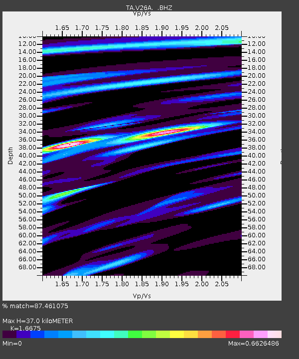
| Estimated Moho Depth: |
37.0 km |
| Estimated Crust Vp/Vs: |
1.67 |
| Assumed Crust Vp: |
6.242 km/s |
| Estimated Crust Vs: |
3.743 km/s |
| Estimated Crust Poisson's Ratio: |
0.22 |
|
| Radial Match: |
87.461075 % |
| Radial Bump: |
400 |
| Transverse Match: |
63.30962 % |
| Transverse Bump: |
400 |
| SOD ConfigId: |
2556 |
| Insert Time: |
2010-03-06 18:39:47.355 +0000 |
| GWidth: |
2.5 |
| Max Bumps: |
400 |
| Tol: |
0.001 |
|

Signal To Noise
| Channel | StoN | STA | LTA |
| TA:V26A: :BHZ:20081007T10:08:27.750005Z | 3.8499832 | 4.1404047E-7 | 1.0754345E-7 |
| TA:V26A: :BHN:20081007T10:08:27.750005Z | 2.1412418 | 2.0896071E-7 | 9.758856E-8 |
| TA:V26A: :BHE:20081007T10:08:27.750005Z | 1.5034935 | 1.269718E-7 | 8.445117E-8 |
| Arrivals |
| Ps | 4.2 SECOND |
| PpPs | 15 SECOND |
| PsPs/PpSs | 19 SECOND |


