You are here: Home > Network List > CN - Canadian National Seismograph Network Stations List
> Station INK INUVIK, NT > Earthquake Result Viewer
INK INUVIK, NT - Earthquake Result Viewer
*The percent match for this event was below the threshold and hence no stack was calculated.
| Earthquake location: |
New Britain Region, P.N.G. |
| Earthquake latitude/longitude: |
-5.0/152.3 |
| Earthquake time(UTC): |
2018/12/17 (351) 11:14:23 GMT |
| Earthquake Depth: |
60 km |
| Earthquake Magnitude: |
5.5 mb |
| Earthquake Catalog/Contributor: |
NEIC PDE/us |
|
| Network: |
CN Canadian National Seismograph Network |
| Station: |
INK INUVIK, NT |
| Lat/Lon: |
68.31 N/133.53 W |
| Elevation: |
44 m |
|
| Distance: |
88.8 deg |
| Az: |
20.96 deg |
| Baz: |
253.435 deg |
| Ray Param: |
$rayparam |
*The percent match for this event was below the threshold and hence was not used in the summary stack. |
|
| Radial Match: |
47.10131 % |
| Radial Bump: |
400 |
| Transverse Match: |
62.690975 % |
| Transverse Bump: |
400 |
| SOD ConfigId: |
13570011 |
| Insert Time: |
2019-05-02 01:54:21.342 +0000 |
| GWidth: |
2.5 |
| Max Bumps: |
400 |
| Tol: |
0.001 |
|
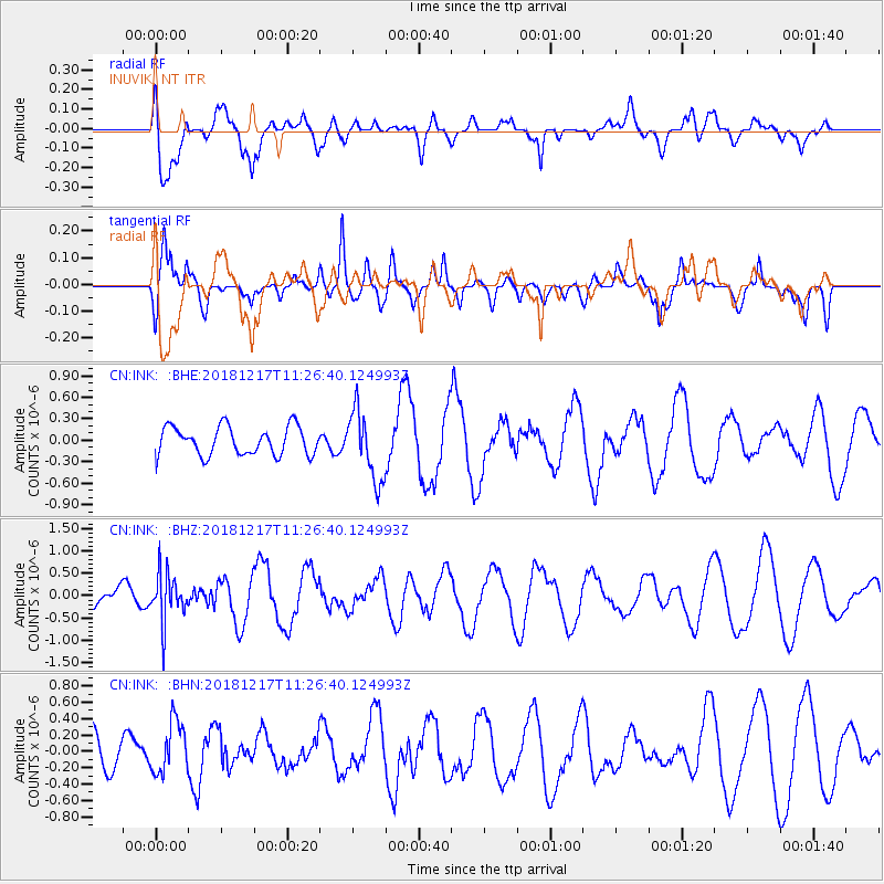
Signal To Noise
| Channel | StoN | STA | LTA |
| CN:INK: :BHZ:20181217T11:26:40.124993Z | 1.5729764 | 5.4631306E-7 | 3.473117E-7 |
| CN:INK: :BHN:20181217T11:26:40.124993Z | 1.2731677 | 3.1884957E-7 | 2.50438E-7 |
| CN:INK: :BHE:20181217T11:26:40.124993Z | 2.4527695 | 4.8492456E-7 | 1.9770489E-7 |
| Arrivals |
| Ps | |
| PpPs | |
| PsPs/PpSs | |


