You are here: Home > Network List > TA - USArray Transportable Network (new EarthScope stations) Stations List
> Station V26A Tequesquite Ranch, Mosquero, NM, USA > Earthquake Result Viewer
V26A Tequesquite Ranch, Mosquero, NM, USA - Earthquake Result Viewer
| Earthquake location: |
Near S. Coast Of Honshu, Japan |
| Earthquake latitude/longitude: |
33.2/137.9 |
| Earthquake time(UTC): |
2009/08/09 (221) 10:55:55 GMT |
| Earthquake Depth: |
297 km |
| Earthquake Magnitude: |
6.5 MB, 7.1 MW, 7.1 MW |
| Earthquake Catalog/Contributor: |
WHDF/NEIC |
|
| Network: |
TA USArray Transportable Network (new EarthScope stations) |
| Station: |
V26A Tequesquite Ranch, Mosquero, NM, USA |
| Lat/Lon: |
35.80 N/103.79 W |
| Elevation: |
1362 m |
|
| Distance: |
90.3 deg |
| Az: |
45.724 deg |
| Baz: |
312.379 deg |
| Ray Param: |
0.04161127 |
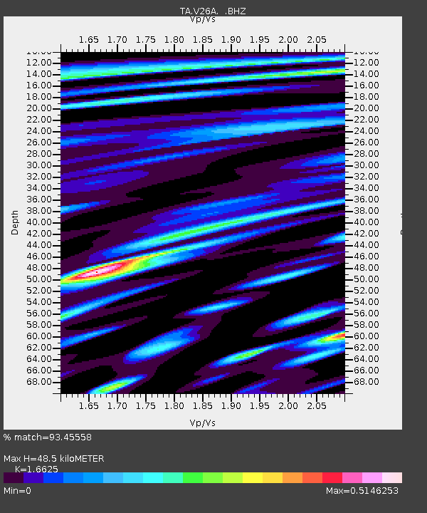
| Estimated Moho Depth: |
48.5 km |
| Estimated Crust Vp/Vs: |
1.66 |
| Assumed Crust Vp: |
6.242 km/s |
| Estimated Crust Vs: |
3.755 km/s |
| Estimated Crust Poisson's Ratio: |
0.22 |
|
| Radial Match: |
93.45558 % |
| Radial Bump: |
400 |
| Transverse Match: |
80.14407 % |
| Transverse Bump: |
400 |
| SOD ConfigId: |
2622 |
| Insert Time: |
2010-03-06 18:40:07.086 +0000 |
| GWidth: |
2.5 |
| Max Bumps: |
400 |
| Tol: |
0.001 |
|

Signal To Noise
| Channel | StoN | STA | LTA |
| TA:V26A: :BHZ:20090809T11:07:51.925002Z | 58.98486 | 5.0146527E-6 | 8.501593E-8 |
| TA:V26A: :BHN:20090809T11:07:51.925002Z | 14.159184 | 1.1503863E-6 | 8.124665E-8 |
| TA:V26A: :BHE:20090809T11:07:51.925002Z | 11.759656 | 9.1297034E-7 | 7.7635804E-8 |
| Arrivals |
| Ps | 5.3 SECOND |
| PpPs | 20 SECOND |
| PsPs/PpSs | 26 SECOND |


