You are here: Home > Network List > TA - USArray Transportable Network (new EarthScope stations) Stations List
> Station V26A Tequesquite Ranch, Mosquero, NM, USA > Earthquake Result Viewer
V26A Tequesquite Ranch, Mosquero, NM, USA - Earthquake Result Viewer
| Earthquake location: |
Off Coast Of Costa Rica |
| Earthquake latitude/longitude: |
7.9/-85.6 |
| Earthquake time(UTC): |
2009/08/13 (225) 09:37:35 GMT |
| Earthquake Depth: |
10 km |
| Earthquake Magnitude: |
5.8 MW, 5.3 MB |
| Earthquake Catalog/Contributor: |
WHDF/NEIC |
|
| Network: |
TA USArray Transportable Network (new EarthScope stations) |
| Station: |
V26A Tequesquite Ranch, Mosquero, NM, USA |
| Lat/Lon: |
35.80 N/103.79 W |
| Elevation: |
1362 m |
|
| Distance: |
32.3 deg |
| Az: |
331.715 deg |
| Baz: |
144.735 deg |
| Ray Param: |
0.07870597 |
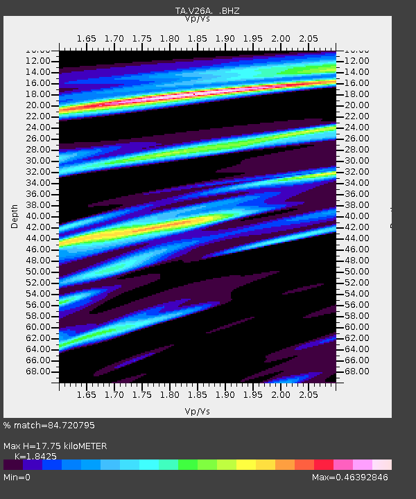
| Estimated Moho Depth: |
17.75 km |
| Estimated Crust Vp/Vs: |
1.84 |
| Assumed Crust Vp: |
6.242 km/s |
| Estimated Crust Vs: |
3.388 km/s |
| Estimated Crust Poisson's Ratio: |
0.29 |
|
| Radial Match: |
84.720795 % |
| Radial Bump: |
268 |
| Transverse Match: |
76.133934 % |
| Transverse Bump: |
400 |
| SOD ConfigId: |
2622 |
| Insert Time: |
2010-03-06 18:40:09.340 +0000 |
| GWidth: |
2.5 |
| Max Bumps: |
400 |
| Tol: |
0.001 |
|

Signal To Noise
| Channel | StoN | STA | LTA |
| TA:V26A: :BHZ:20090813T09:43:33.700006Z | 5.3834434 | 3.3418826E-7 | 6.207705E-8 |
| TA:V26A: :BHN:20090813T09:43:33.700006Z | 2.3557367 | 1.8740239E-7 | 7.9551505E-8 |
| TA:V26A: :BHE:20090813T09:43:33.700006Z | 2.8446085 | 1.8195722E-7 | 6.396564E-8 |
| Arrivals |
| Ps | 2.6 SECOND |
| PpPs | 7.5 SECOND |
| PsPs/PpSs | 10 SECOND |


