You are here: Home > Network List > TA - USArray Transportable Network (new EarthScope stations) Stations List
> Station D23K Nanushuk River, AK USA > Earthquake Result Viewer
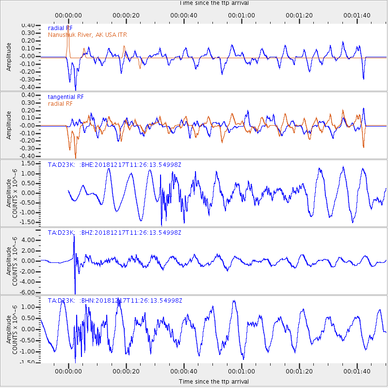
D23K Nanushuk River, AK USA - Earthquake Result Viewer
*The percent match for this event was below the threshold and hence no stack was calculated.
| Earthquake location: |
New Britain Region, P.N.G. |
| Earthquake latitude/longitude: |
-5.0/152.3 |
| Earthquake time(UTC): |
2018/12/17 (351) 11:14:23 GMT |
| Earthquake Depth: |
60 km |
| Earthquake Magnitude: |
5.5 mb |
| Earthquake Catalog/Contributor: |
NEIC PDE/us |
|
| Network: |
TA USArray Transportable Network (new EarthScope stations) |
| Station: |
D23K Nanushuk River, AK USA |
| Lat/Lon: |
68.97 N/150.68 W |
| Elevation: |
406 m |
|
| Distance: |
83.4 deg |
| Az: |
17.744 deg |
| Baz: |
237.239 deg |
| Ray Param: |
$rayparam |
*The percent match for this event was below the threshold and hence was not used in the summary stack. |
|
| Radial Match: |
58.104244 % |
| Radial Bump: |
400 |
| Transverse Match: |
49.61306 % |
| Transverse Bump: |
400 |
| SOD ConfigId: |
13570011 |
| Insert Time: |
2019-05-02 01:56:16.440 +0000 |
| GWidth: |
2.5 |
| Max Bumps: |
400 |
| Tol: |
0.001 |
|
Signal To Noise
| Channel | StoN | STA | LTA |
| TA:D23K: :BHZ:20181217T11:26:13.54998Z | 4.039953 | 1.710613E-6 | 4.2342396E-7 |
| TA:D23K: :BHN:20181217T11:26:13.54998Z | 0.98156375 | 6.103293E-7 | 6.217929E-7 |
| TA:D23K: :BHE:20181217T11:26:13.54998Z | 1.0531728 | 5.832225E-7 | 5.5377666E-7 |
| Arrivals |
| Ps | |
| PpPs | |
| PsPs/PpSs | |


