You are here: Home > Network List > TA - USArray Transportable Network (new EarthScope stations) Stations List
> Station E20K Nigu River, AK, USA > Earthquake Result Viewer
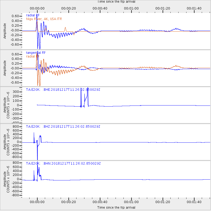
E20K Nigu River, AK, USA - Earthquake Result Viewer
*The percent match for this event was below the threshold and hence no stack was calculated.
| Earthquake location: |
New Britain Region, P.N.G. |
| Earthquake latitude/longitude: |
-5.0/152.3 |
| Earthquake time(UTC): |
2018/12/17 (351) 11:14:23 GMT |
| Earthquake Depth: |
60 km |
| Earthquake Magnitude: |
5.5 mb |
| Earthquake Catalog/Contributor: |
NEIC PDE/us |
|
| Network: |
TA USArray Transportable Network (new EarthScope stations) |
| Station: |
E20K Nigu River, AK, USA |
| Lat/Lon: |
68.26 N/156.19 W |
| Elevation: |
866 m |
|
| Distance: |
81.4 deg |
| Az: |
17.15 deg |
| Baz: |
232.036 deg |
| Ray Param: |
$rayparam |
*The percent match for this event was below the threshold and hence was not used in the summary stack. |
|
| Radial Match: |
29.674543 % |
| Radial Bump: |
400 |
| Transverse Match: |
43.603813 % |
| Transverse Bump: |
400 |
| SOD ConfigId: |
13570011 |
| Insert Time: |
2019-05-02 01:56:20.369 +0000 |
| GWidth: |
2.5 |
| Max Bumps: |
400 |
| Tol: |
0.001 |
|
Signal To Noise
| Channel | StoN | STA | LTA |
| TA:E20K: :BHZ:20181217T11:26:02.850029Z | 35.979534 | 1.9903887E-4 | 5.532002E-6 |
| TA:E20K: :BHN:20181217T11:26:02.850029Z | 14.789253 | 2.3504566E-4 | 1.5893003E-5 |
| TA:E20K: :BHE:20181217T11:26:02.850029Z | 15.002798 | 1.4152534E-4 | 9.433263E-6 |
| Arrivals |
| Ps | |
| PpPs | |
| PsPs/PpSs | |


