You are here: Home > Network List > TA - USArray Transportable Network (new EarthScope stations) Stations List
> Station V26A Tequesquite Ranch, Mosquero, NM, USA > Earthquake Result Viewer
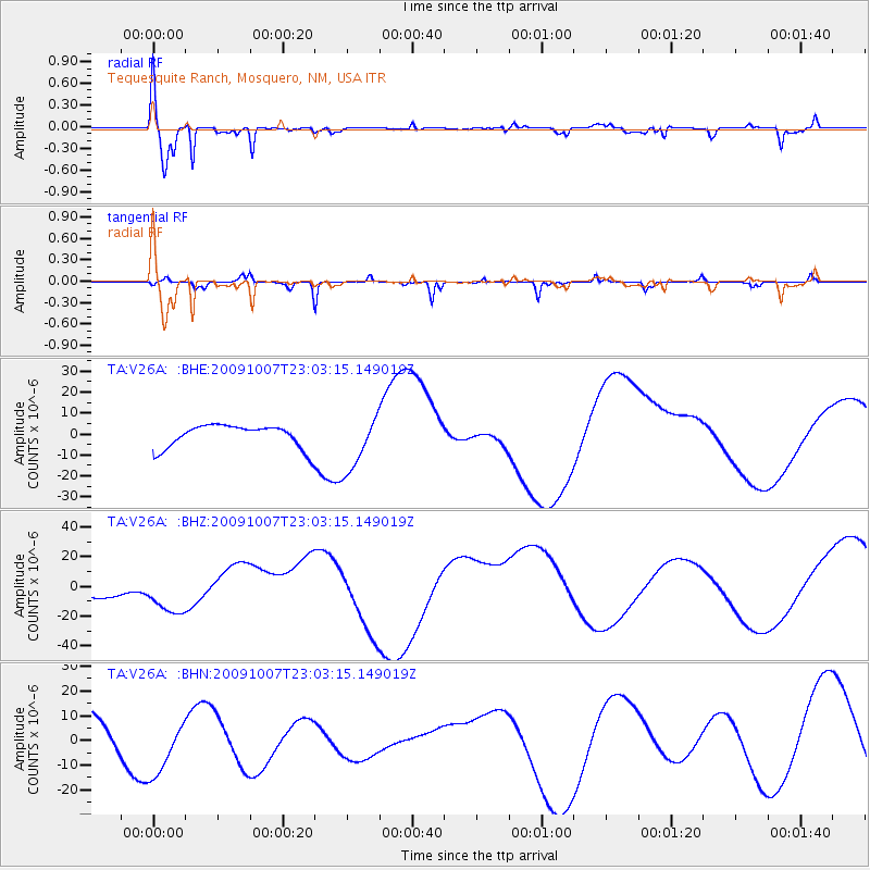
V26A Tequesquite Ranch, Mosquero, NM, USA - Earthquake Result Viewer
| Earthquake location: |
Santa Cruz Islands |
| Earthquake latitude/longitude: |
-12.4/166.1 |
| Earthquake time(UTC): |
2009/10/07 (280) 22:50:15 GMT |
| Earthquake Depth: |
21 km |
| Earthquake Magnitude: |
5.8 MB |
| Earthquake Catalog/Contributor: |
WHDF/NEIC |
|
| Network: |
TA USArray Transportable Network (new EarthScope stations) |
| Station: |
V26A Tequesquite Ranch, Mosquero, NM, USA |
| Lat/Lon: |
35.80 N/103.79 W |
| Elevation: |
1362 m |
|
| Distance: |
97.2 deg |
| Az: |
55.033 deg |
| Baz: |
260.013 deg |
| Ray Param: |
0.04026848 |
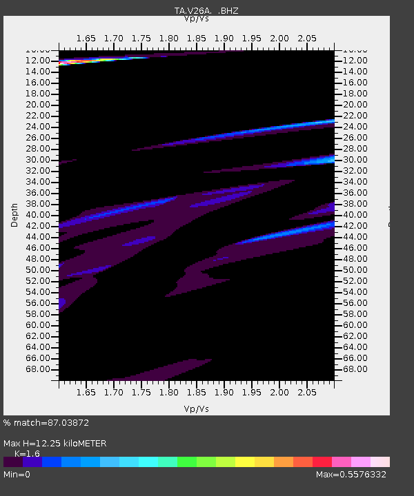
| Estimated Moho Depth: |
12.25 km |
| Estimated Crust Vp/Vs: |
1.60 |
| Assumed Crust Vp: |
6.242 km/s |
| Estimated Crust Vs: |
3.901 km/s |
| Estimated Crust Poisson's Ratio: |
0.18 |
|
| Radial Match: |
87.03872 % |
| Radial Bump: |
400 |
| Transverse Match: |
83.46664 % |
| Transverse Bump: |
177 |
| SOD ConfigId: |
2622 |
| Insert Time: |
2010-03-06 18:40:25.162 +0000 |
| GWidth: |
2.5 |
| Max Bumps: |
400 |
| Tol: |
0.001 |
|
Signal To Noise
| Channel | StoN | STA | LTA |
| TA:V26A: :BHZ:20091007T23:03:15.149019Z | 1.090338 | 1.4365224E-5 | 1.3175019E-5 |
| TA:V26A: :BHN:20091007T23:03:15.149019Z | 2.060837 | 1.1981857E-5 | 5.814073E-6 |
| TA:V26A: :BHE:20091007T23:03:15.149019Z | 2.4304743 | 1.3291499E-5 | 5.4686852E-6 |
| Arrivals |
| Ps | 1.2 SECOND |
| PpPs | 5.0 SECOND |
| PsPs/PpSs | 6.2 SECOND |


