You are here: Home > Network List > TA - USArray Transportable Network (new EarthScope stations) Stations List
> Station G31M Satah River, YT, CAN > Earthquake Result Viewer
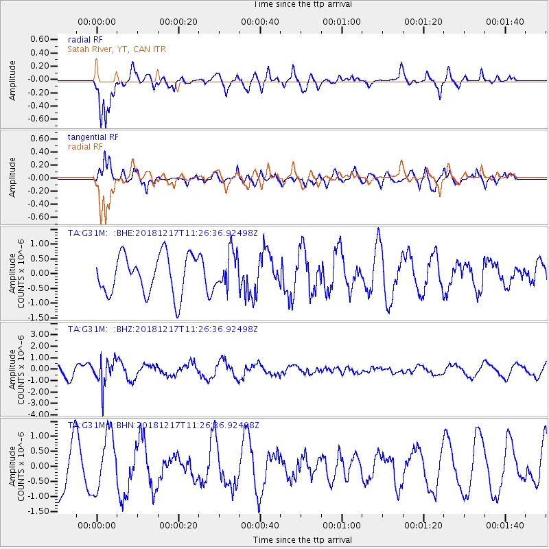
G31M Satah River, YT, CAN - Earthquake Result Viewer
*The percent match for this event was below the threshold and hence no stack was calculated.
| Earthquake location: |
New Britain Region, P.N.G. |
| Earthquake latitude/longitude: |
-5.0/152.3 |
| Earthquake time(UTC): |
2018/12/17 (351) 11:14:23 GMT |
| Earthquake Depth: |
60 km |
| Earthquake Magnitude: |
5.5 mb |
| Earthquake Catalog/Contributor: |
NEIC PDE/us |
|
| Network: |
TA USArray Transportable Network (new EarthScope stations) |
| Station: |
G31M Satah River, YT, CAN |
| Lat/Lon: |
66.92 N/134.27 W |
| Elevation: |
61 m |
|
| Distance: |
88.2 deg |
| Az: |
22.208 deg |
| Baz: |
252.779 deg |
| Ray Param: |
$rayparam |
*The percent match for this event was below the threshold and hence was not used in the summary stack. |
|
| Radial Match: |
72.504845 % |
| Radial Bump: |
400 |
| Transverse Match: |
75.86284 % |
| Transverse Bump: |
400 |
| SOD ConfigId: |
13570011 |
| Insert Time: |
2019-05-02 01:56:35.216 +0000 |
| GWidth: |
2.5 |
| Max Bumps: |
400 |
| Tol: |
0.001 |
|
Signal To Noise
| Channel | StoN | STA | LTA |
| TA:G31M: :BHZ:20181217T11:26:36.92498Z | 2.5287094 | 1.1304867E-6 | 4.4706073E-7 |
| TA:G31M: :BHN:20181217T11:26:36.92498Z | 1.3142364 | 9.488762E-7 | 7.2199816E-7 |
| TA:G31M: :BHE:20181217T11:26:36.92498Z | 0.9202143 | 6.1053885E-7 | 6.634746E-7 |
| Arrivals |
| Ps | |
| PpPs | |
| PsPs/PpSs | |


