You are here: Home > Network List > TA - USArray Transportable Network (new EarthScope stations) Stations List
> Station V26A Tequesquite Ranch, Mosquero, NM, USA > Earthquake Result Viewer
V26A Tequesquite Ranch, Mosquero, NM, USA - Earthquake Result Viewer
| Earthquake location: |
North Of Svalbard |
| Earthquake latitude/longitude: |
80.3/-1.9 |
| Earthquake time(UTC): |
2009/03/06 (065) 10:50:29 GMT |
| Earthquake Depth: |
9.0 km |
| Earthquake Magnitude: |
6.6 MB, 6.5 MS, 6.5 MW, 6.4 MW |
| Earthquake Catalog/Contributor: |
WHDF/NEIC |
|
| Network: |
TA USArray Transportable Network (new EarthScope stations) |
| Station: |
V26A Tequesquite Ranch, Mosquero, NM, USA |
| Lat/Lon: |
35.80 N/103.79 W |
| Elevation: |
1362 m |
|
| Distance: |
56.9 deg |
| Az: |
288.374 deg |
| Baz: |
11.39 deg |
| Ray Param: |
0.06381399 |
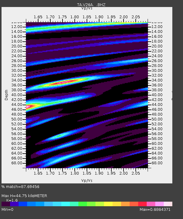
| Estimated Moho Depth: |
44.75 km |
| Estimated Crust Vp/Vs: |
1.60 |
| Assumed Crust Vp: |
6.242 km/s |
| Estimated Crust Vs: |
3.901 km/s |
| Estimated Crust Poisson's Ratio: |
0.18 |
|
| Radial Match: |
87.69456 % |
| Radial Bump: |
393 |
| Transverse Match: |
76.27788 % |
| Transverse Bump: |
400 |
| SOD ConfigId: |
2658 |
| Insert Time: |
2010-03-06 18:40:35.013 +0000 |
| GWidth: |
2.5 |
| Max Bumps: |
400 |
| Tol: |
0.001 |
|

Signal To Noise
| Channel | StoN | STA | LTA |
| TA:V26A: :BHZ:20090306T10:59:43.824001Z | 17.612267 | 2.7085707E-6 | 1.5378887E-7 |
| TA:V26A: :BHN:20090306T10:59:43.824001Z | 8.957344 | 1.1834023E-6 | 1.321153E-7 |
| TA:V26A: :BHE:20090306T10:59:43.824001Z | 1.957403 | 3.7379215E-7 | 1.909633E-7 |
| Arrivals |
| Ps | 4.5 SECOND |
| PpPs | 18 SECOND |
| PsPs/PpSs | 22 SECOND |


