You are here: Home > Network List > CI - Caltech Regional Seismic Network Stations List
> Station MPP McPhearson Peak > Earthquake Result Viewer
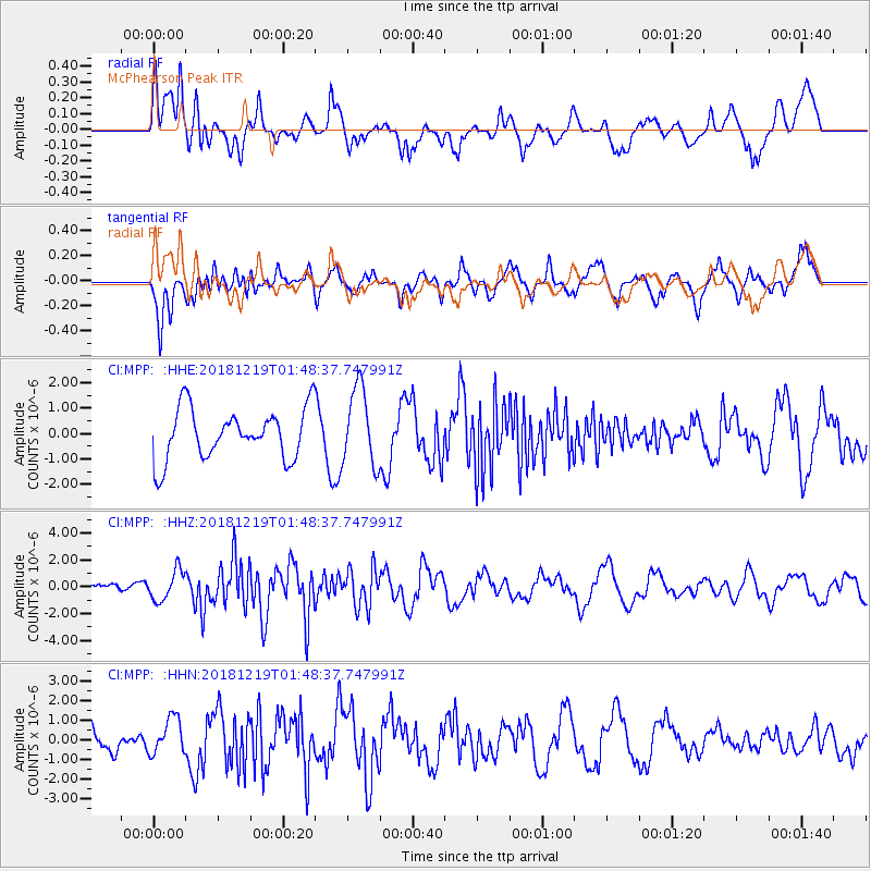
MPP McPhearson Peak - Earthquake Result Viewer
*The percent match for this event was below the threshold and hence no stack was calculated.
| Earthquake location: |
Southeast Of Easter Island |
| Earthquake latitude/longitude: |
-36.1/-101.0 |
| Earthquake time(UTC): |
2018/12/19 (353) 01:37:40 GMT |
| Earthquake Depth: |
10 km |
| Earthquake Magnitude: |
6.2 Mww |
| Earthquake Catalog/Contributor: |
NEIC PDE/us |
|
| Network: |
CI Caltech Regional Seismic Network |
| Station: |
MPP McPhearson Peak |
| Lat/Lon: |
34.89 N/119.81 W |
| Elevation: |
1739 m |
|
| Distance: |
72.8 deg |
| Az: |
343.903 deg |
| Baz: |
164.152 deg |
| Ray Param: |
$rayparam |
*The percent match for this event was below the threshold and hence was not used in the summary stack. |
|
| Radial Match: |
59.59489 % |
| Radial Bump: |
400 |
| Transverse Match: |
73.090324 % |
| Transverse Bump: |
400 |
| SOD ConfigId: |
13570011 |
| Insert Time: |
2019-05-02 01:59:43.586 +0000 |
| GWidth: |
2.5 |
| Max Bumps: |
400 |
| Tol: |
0.001 |
|
Signal To Noise
| Channel | StoN | STA | LTA |
| CI:MPP: :HHZ:20181219T01:48:37.747991Z | 2.2181904 | 1.1182182E-6 | 5.041128E-7 |
| CI:MPP: :HHN:20181219T01:48:37.747991Z | 0.80625296 | 9.1086173E-7 | 1.1297468E-6 |
| CI:MPP: :HHE:20181219T01:48:37.747991Z | 1.5557241 | 1.5287097E-6 | 9.826355E-7 |
| Arrivals |
| Ps | |
| PpPs | |
| PsPs/PpSs | |


