You are here: Home > Network List > GS - US Geological Survey Networks Stations List
> Station OK051 E0350 and S34600 Roads, Ralston, OK > Earthquake Result Viewer
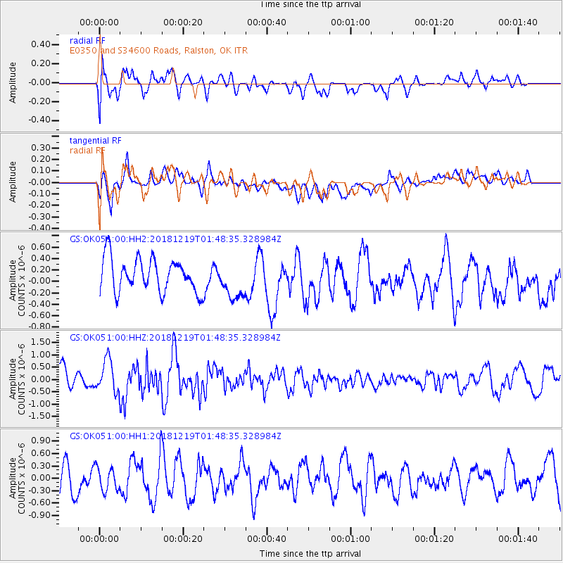
OK051 E0350 and S34600 Roads, Ralston, OK - Earthquake Result Viewer
*The percent match for this event was below the threshold and hence no stack was calculated.
| Earthquake location: |
Southeast Of Easter Island |
| Earthquake latitude/longitude: |
-36.1/-101.0 |
| Earthquake time(UTC): |
2018/12/19 (353) 01:37:40 GMT |
| Earthquake Depth: |
10 km |
| Earthquake Magnitude: |
6.2 Mww |
| Earthquake Catalog/Contributor: |
NEIC PDE/us |
|
| Network: |
GS US Geological Survey Networks |
| Station: |
OK051 E0350 and S34600 Roads, Ralston, OK |
| Lat/Lon: |
36.51 N/96.84 W |
| Elevation: |
263 m |
|
| Distance: |
72.4 deg |
| Az: |
3.536 deg |
| Baz: |
183.553 deg |
| Ray Param: |
$rayparam |
*The percent match for this event was below the threshold and hence was not used in the summary stack. |
|
| Radial Match: |
68.2613 % |
| Radial Bump: |
400 |
| Transverse Match: |
58.253277 % |
| Transverse Bump: |
400 |
| SOD ConfigId: |
13570011 |
| Insert Time: |
2019-05-02 02:00:39.936 +0000 |
| GWidth: |
2.5 |
| Max Bumps: |
400 |
| Tol: |
0.001 |
|
Signal To Noise
| Channel | StoN | STA | LTA |
| GS:OK051:00:HHZ:20181219T01:48:35.328984Z | 1.7450088 | 6.7605697E-7 | 3.8742323E-7 |
| GS:OK051:00:HH1:20181219T01:48:35.328984Z | 0.97043663 | 2.8964075E-7 | 2.9846436E-7 |
| GS:OK051:00:HH2:20181219T01:48:35.328984Z | 1.1797711 | 3.4055265E-7 | 2.8865995E-7 |
| Arrivals |
| Ps | |
| PpPs | |
| PsPs/PpSs | |


