You are here: Home > Network List > GT - Global Telemetered Seismograph Network (USAF/USGS) Stations List
> Station LPAZ La Paz , Bolivia > Earthquake Result Viewer
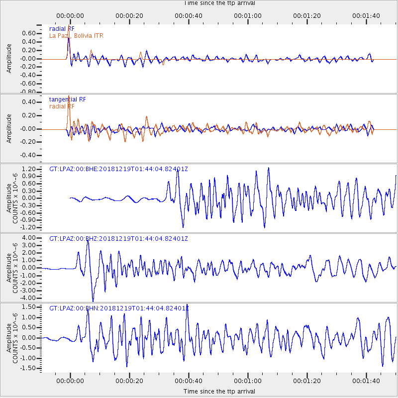
LPAZ La Paz , Bolivia - Earthquake Result Viewer
*The percent match for this event was below the threshold and hence no stack was calculated.
| Earthquake location: |
Southeast Of Easter Island |
| Earthquake latitude/longitude: |
-36.1/-101.0 |
| Earthquake time(UTC): |
2018/12/19 (353) 01:37:40 GMT |
| Earthquake Depth: |
10 km |
| Earthquake Magnitude: |
6.2 Mww |
| Earthquake Catalog/Contributor: |
NEIC PDE/us |
|
| Network: |
GT Global Telemetered Seismograph Network (USAF/USGS) |
| Station: |
LPAZ La Paz , Bolivia |
| Lat/Lon: |
16.17 S/68.08 W |
| Elevation: |
4817 m |
|
| Distance: |
35.4 deg |
| Az: |
64.508 deg |
| Baz: |
229.515 deg |
| Ray Param: |
$rayparam |
*The percent match for this event was below the threshold and hence was not used in the summary stack. |
|
| Radial Match: |
73.282524 % |
| Radial Bump: |
400 |
| Transverse Match: |
69.07919 % |
| Transverse Bump: |
400 |
| SOD ConfigId: |
13570011 |
| Insert Time: |
2019-05-02 02:00:40.802 +0000 |
| GWidth: |
2.5 |
| Max Bumps: |
400 |
| Tol: |
0.001 |
|
Signal To Noise
| Channel | StoN | STA | LTA |
| GT:LPAZ:00:BHZ:20181219T01:44:04.82401Z | 8.014729 | 8.030366E-7 | 1.0019511E-7 |
| GT:LPAZ:00:BHN:20181219T01:44:04.82401Z | 2.7807612 | 2.2758753E-7 | 8.184361E-8 |
| GT:LPAZ:00:BHE:20181219T01:44:04.82401Z | 4.163628 | 2.6049156E-7 | 6.256359E-8 |
| Arrivals |
| Ps | |
| PpPs | |
| PsPs/PpSs | |


