You are here: Home > Network List > TA - USArray Transportable Network (new EarthScope stations) Stations List
> Station V26A Tequesquite Ranch, Mosquero, NM, USA > Earthquake Result Viewer
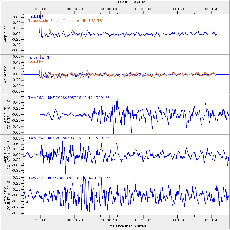
V26A Tequesquite Ranch, Mosquero, NM, USA - Earthquake Result Viewer
*The percent match for this event was below the threshold and hence no stack was calculated.
| Earthquake location: |
Trinidad |
| Earthquake latitude/longitude: |
10.3/-60.4 |
| Earthquake time(UTC): |
2008/07/03 (185) 06:34:53 GMT |
| Earthquake Depth: |
34 km |
| Earthquake Magnitude: |
5.7 MB, 5.5 MS, 5.8 MW, 5.7 MW |
| Earthquake Catalog/Contributor: |
WHDF/NEIC |
|
| Network: |
TA USArray Transportable Network (new EarthScope stations) |
| Station: |
V26A Tequesquite Ranch, Mosquero, NM, USA |
| Lat/Lon: |
35.80 N/103.79 W |
| Elevation: |
1362 m |
|
| Distance: |
46.8 deg |
| Az: |
310.003 deg |
| Baz: |
111.979 deg |
| Ray Param: |
$rayparam |
*The percent match for this event was below the threshold and hence was not used in the summary stack. |
|
| Radial Match: |
70.47832 % |
| Radial Bump: |
400 |
| Transverse Match: |
60.136715 % |
| Transverse Bump: |
400 |
| SOD ConfigId: |
2504 |
| Insert Time: |
2010-03-06 18:41:08.847 +0000 |
| GWidth: |
2.5 |
| Max Bumps: |
400 |
| Tol: |
0.001 |
|
Signal To Noise
| Channel | StoN | STA | LTA |
| TA:V26A: :BHZ:20080703T06:42:49.150012Z | 2.2362733 | 2.0271567E-7 | 9.0648875E-8 |
| TA:V26A: :BHN:20080703T06:42:49.150012Z | 1.0157261 | 5.0431556E-8 | 4.9650748E-8 |
| TA:V26A: :BHE:20080703T06:42:49.150012Z | 1.9462438 | 1.218142E-7 | 6.2589386E-8 |
| Arrivals |
| Ps | |
| PpPs | |
| PsPs/PpSs | |


