You are here: Home > Network List > AG - Arkansas Seismic Network Stations List
> Station LCAR Lake Charles,AR > Earthquake Result Viewer
LCAR Lake Charles,AR - Earthquake Result Viewer
| Earthquake location: |
North Of Ascension Island |
| Earthquake latitude/longitude: |
-0.0/-17.8 |
| Earthquake time(UTC): |
2016/08/29 (242) 04:29:57 GMT |
| Earthquake Depth: |
10 km |
| Earthquake Magnitude: |
7.1 MWW, 7.1 MWC, 7.4 MI |
| Earthquake Catalog/Contributor: |
NEIC PDE/NEIC COMCAT |
|
| Network: |
AG Arkansas Seismic Network |
| Station: |
LCAR Lake Charles,AR |
| Lat/Lon: |
36.07 N/91.15 W |
| Elevation: |
103 m |
|
| Distance: |
76.6 deg |
| Az: |
307.073 deg |
| Baz: |
99.997 deg |
| Ray Param: |
0.050895408 |
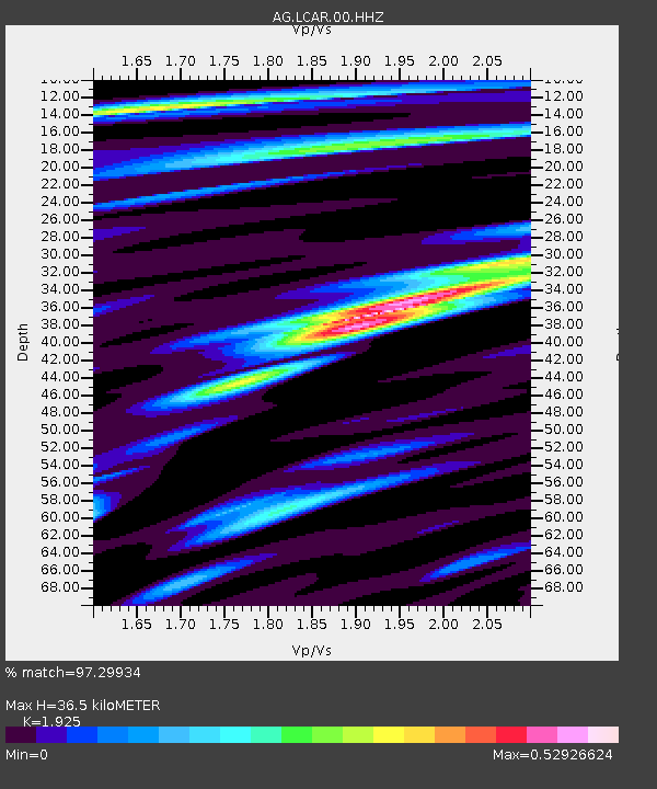
| Estimated Moho Depth: |
36.5 km |
| Estimated Crust Vp/Vs: |
1.92 |
| Assumed Crust Vp: |
6.53 km/s |
| Estimated Crust Vs: |
3.392 km/s |
| Estimated Crust Poisson's Ratio: |
0.32 |
|
| Radial Match: |
97.29934 % |
| Radial Bump: |
247 |
| Transverse Match: |
91.91841 % |
| Transverse Bump: |
363 |
| SOD ConfigId: |
1634031 |
| Insert Time: |
2016-09-12 04:30:06.720 +0000 |
| GWidth: |
2.5 |
| Max Bumps: |
400 |
| Tol: |
0.001 |
|

Signal To Noise
| Channel | StoN | STA | LTA |
| AG:LCAR:00:HHZ:20160829T04:41:17.064998Z | 4.417589 | 2.9994877E-7 | 6.789875E-8 |
| AG:LCAR:00:HHN:20160829T04:41:17.064998Z | 0.64984375 | 3.38916E-8 | 5.2153457E-8 |
| AG:LCAR:00:HHE:20160829T04:41:17.064998Z | 3.3837852 | 1.5698093E-7 | 4.639211E-8 |
| Arrivals |
| Ps | 5.3 SECOND |
| PpPs | 16 SECOND |
| PsPs/PpSs | 21 SECOND |


