You are here: Home > Network List > TA - USArray Transportable Network (new EarthScope stations) Stations List
> Station I30M Mount Dempster, Yukon, CAN > Earthquake Result Viewer
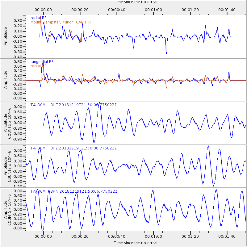
I30M Mount Dempster, Yukon, CAN - Earthquake Result Viewer
*The percent match for this event was below the threshold and hence no stack was calculated.
| Earthquake location: |
New Britain Region, P.N.G. |
| Earthquake latitude/longitude: |
-6.1/149.8 |
| Earthquake time(UTC): |
2018/12/19 (353) 21:37:45 GMT |
| Earthquake Depth: |
8.7 km |
| Earthquake Magnitude: |
5.7 Mww |
| Earthquake Catalog/Contributor: |
NEIC PDE/us |
|
| Network: |
TA USArray Transportable Network (new EarthScope stations) |
| Station: |
I30M Mount Dempster, Yukon, CAN |
| Lat/Lon: |
65.22 N/136.38 W |
| Elevation: |
1399 m |
|
| Distance: |
88.8 deg |
| Az: |
23.875 deg |
| Baz: |
252.751 deg |
| Ray Param: |
$rayparam |
*The percent match for this event was below the threshold and hence was not used in the summary stack. |
|
| Radial Match: |
44.837658 % |
| Radial Bump: |
358 |
| Transverse Match: |
80.749306 % |
| Transverse Bump: |
400 |
| SOD ConfigId: |
13570011 |
| Insert Time: |
2019-05-02 02:10:08.288 +0000 |
| GWidth: |
2.5 |
| Max Bumps: |
400 |
| Tol: |
0.001 |
|
Signal To Noise
| Channel | StoN | STA | LTA |
| TA:I30M: :BHZ:20181219T21:50:06.775022Z | 1.2600653 | 4.6746374E-7 | 3.709837E-7 |
| TA:I30M: :BHN:20181219T21:50:06.775022Z | 1.884407 | 5.987702E-7 | 3.1774994E-7 |
| TA:I30M: :BHE:20181219T21:50:06.775022Z | 1.4632231 | 6.3616625E-7 | 4.347705E-7 |
| Arrivals |
| Ps | |
| PpPs | |
| PsPs/PpSs | |


