You are here: Home > Network List > TS - TERRAscope (Southern California Seismic Network) Stations List
> Station BAR Barrett Dam, California, USA > Earthquake Result Viewer
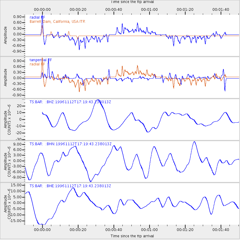
BAR Barrett Dam, California, USA - Earthquake Result Viewer
*The percent match for this event was below the threshold and hence no stack was calculated.
| Earthquake location: |
Near Coast Of Peru |
| Earthquake latitude/longitude: |
-14.9/-75.6 |
| Earthquake time(UTC): |
1996/11/12 (317) 17:10:00 GMT |
| Earthquake Depth: |
33 km |
| Earthquake Magnitude: |
5.6 MB |
| Earthquake Catalog/Contributor: |
WHDF/NEIC |
|
| Network: |
TS TERRAscope (Southern California Seismic Network) |
| Station: |
BAR Barrett Dam, California, USA |
| Lat/Lon: |
32.68 N/116.67 W |
| Elevation: |
548 m |
|
| Distance: |
61.5 deg |
| Az: |
320.926 deg |
| Baz: |
133.74 deg |
| Ray Param: |
$rayparam |
*The percent match for this event was below the threshold and hence was not used in the summary stack. |
|
| Radial Match: |
49.778378 % |
| Radial Bump: |
400 |
| Transverse Match: |
64.48422 % |
| Transverse Bump: |
400 |
| SOD ConfigId: |
4480 |
| Insert Time: |
2010-02-26 14:01:56.432 +0000 |
| GWidth: |
2.5 |
| Max Bumps: |
400 |
| Tol: |
0.001 |
|
Signal To Noise
| Channel | StoN | STA | LTA |
| TS:BAR: :BHN:19961112T17:19:43.238013Z | 0.94881153 | 5.1700167E-6 | 5.448939E-6 |
| TS:BAR: :BHE:19961112T17:19:43.238013Z | 2.4720504 | 2.110915E-5 | 8.539126E-6 |
| TS:BAR: :BHZ:19961112T17:19:43.238013Z | 3.5012422 | 2.8639754E-5 | 8.1798835E-6 |
| Arrivals |
| Ps | |
| PpPs | |
| PsPs/PpSs | |


