You are here: Home > Network List > CA - Catalan Seismic Network Stations List
> Station CBRU Bruguera > Earthquake Result Viewer
CBRU Bruguera - Earthquake Result Viewer
| Earthquake location: |
Komandorskiye Ostrova Region |
| Earthquake latitude/longitude: |
54.8/164.8 |
| Earthquake time(UTC): |
2018/12/20 (354) 17:01:56 GMT |
| Earthquake Depth: |
33 km |
| Earthquake Magnitude: |
7.3 Mi |
| Earthquake Catalog/Contributor: |
NEIC PDE/pt |
|
| Network: |
CA Catalan Seismic Network |
| Station: |
CBRU Bruguera |
| Lat/Lon: |
42.28 N/2.18 E |
| Elevation: |
1327 m |
|
| Distance: |
82.1 deg |
| Az: |
347.09 deg |
| Baz: |
10.028 deg |
| Ray Param: |
0.04706971 |
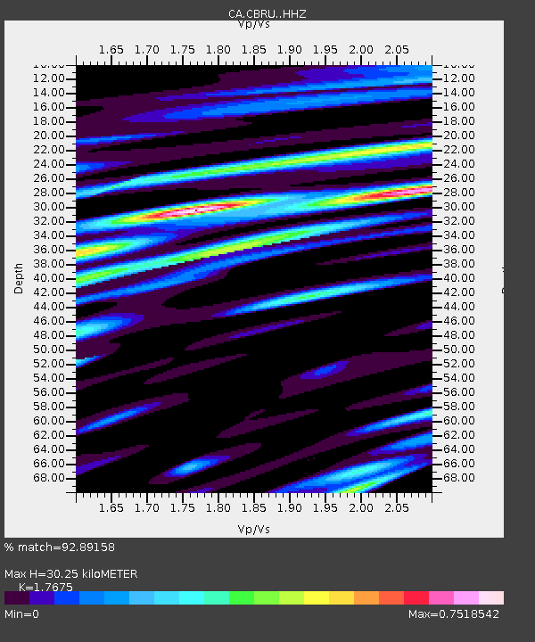
| Estimated Moho Depth: |
30.25 km |
| Estimated Crust Vp/Vs: |
1.77 |
| Assumed Crust Vp: |
6.264 km/s |
| Estimated Crust Vs: |
3.544 km/s |
| Estimated Crust Poisson's Ratio: |
0.26 |
|
| Radial Match: |
92.89158 % |
| Radial Bump: |
400 |
| Transverse Match: |
83.78071 % |
| Transverse Bump: |
400 |
| SOD ConfigId: |
13570011 |
| Insert Time: |
2019-05-02 02:13:04.701 +0000 |
| GWidth: |
2.5 |
| Max Bumps: |
400 |
| Tol: |
0.001 |
|

Signal To Noise
| Channel | StoN | STA | LTA |
| CA:CBRU: :HHZ:20181220T17:13:41.950012Z | 17.445063 | 5.59246E-6 | 3.2057554E-7 |
| CA:CBRU: :HHN:20181220T17:13:41.950012Z | 7.9269886 | 1.346753E-6 | 1.6989465E-7 |
| CA:CBRU: :HHE:20181220T17:13:41.950012Z | 4.6064377 | 1.0626832E-6 | 2.3069522E-7 |
| Arrivals |
| Ps | 3.8 SECOND |
| PpPs | 13 SECOND |
| PsPs/PpSs | 17 SECOND |


