You are here: Home > Network List > CA - Catalan Seismic Network Stations List
> Station CPAL Palau-saverdera > Earthquake Result Viewer
CPAL Palau-saverdera - Earthquake Result Viewer
| Earthquake location: |
Komandorskiye Ostrova Region |
| Earthquake latitude/longitude: |
54.8/164.8 |
| Earthquake time(UTC): |
2018/12/20 (354) 17:01:56 GMT |
| Earthquake Depth: |
33 km |
| Earthquake Magnitude: |
7.3 Mi |
| Earthquake Catalog/Contributor: |
NEIC PDE/pt |
|
| Network: |
CA Catalan Seismic Network |
| Station: |
CPAL Palau-saverdera |
| Lat/Lon: |
42.31 N/3.16 E |
| Elevation: |
212 m |
|
| Distance: |
82.0 deg |
| Az: |
346.369 deg |
| Baz: |
10.587 deg |
| Ray Param: |
0.047178537 |
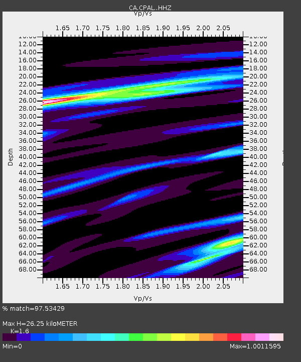
| Estimated Moho Depth: |
26.25 km |
| Estimated Crust Vp/Vs: |
1.60 |
| Assumed Crust Vp: |
6.264 km/s |
| Estimated Crust Vs: |
3.915 km/s |
| Estimated Crust Poisson's Ratio: |
0.18 |
|
| Radial Match: |
97.53429 % |
| Radial Bump: |
298 |
| Transverse Match: |
91.08497 % |
| Transverse Bump: |
400 |
| SOD ConfigId: |
13570011 |
| Insert Time: |
2019-05-02 02:13:13.369 +0000 |
| GWidth: |
2.5 |
| Max Bumps: |
400 |
| Tol: |
0.001 |
|

Signal To Noise
| Channel | StoN | STA | LTA |
| CA:CPAL: :HHZ:20181220T17:13:41.130005Z | 25.987616 | 5.608804E-6 | 2.1582603E-7 |
| CA:CPAL: :HHN:20181220T17:13:41.130005Z | 11.753522 | 2.196873E-6 | 1.8691189E-7 |
| CA:CPAL: :HHE:20181220T17:13:41.130005Z | 1.3931787 | 3.122945E-7 | 2.2415969E-7 |
| Arrivals |
| Ps | 2.6 SECOND |
| PpPs | 11 SECOND |
| PsPs/PpSs | 13 SECOND |


