You are here: Home > Network List > CA - Catalan Seismic Network Stations List
> Station CSOR Soriguera > Earthquake Result Viewer
CSOR Soriguera - Earthquake Result Viewer
| Earthquake location: |
Komandorskiye Ostrova Region |
| Earthquake latitude/longitude: |
54.8/164.8 |
| Earthquake time(UTC): |
2018/12/20 (354) 17:01:56 GMT |
| Earthquake Depth: |
33 km |
| Earthquake Magnitude: |
7.3 Mi |
| Earthquake Catalog/Contributor: |
NEIC PDE/pt |
|
| Network: |
CA Catalan Seismic Network |
| Station: |
CSOR Soriguera |
| Lat/Lon: |
42.37 N/1.13 E |
| Elevation: |
1227 m |
|
| Distance: |
82.2 deg |
| Az: |
347.877 deg |
| Baz: |
9.434 deg |
| Ray Param: |
0.047040306 |
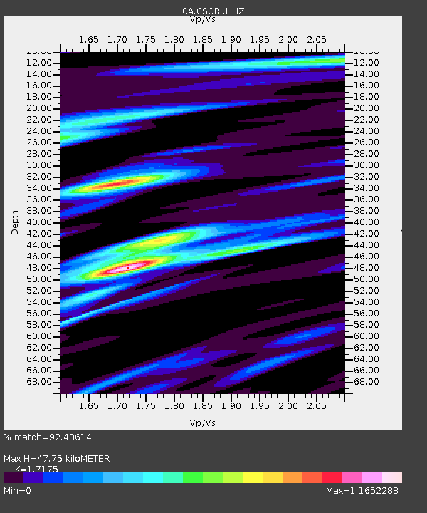
| Estimated Moho Depth: |
47.75 km |
| Estimated Crust Vp/Vs: |
1.72 |
| Assumed Crust Vp: |
6.416 km/s |
| Estimated Crust Vs: |
3.736 km/s |
| Estimated Crust Poisson's Ratio: |
0.24 |
|
| Radial Match: |
92.48614 % |
| Radial Bump: |
400 |
| Transverse Match: |
75.84449 % |
| Transverse Bump: |
400 |
| SOD ConfigId: |
13570011 |
| Insert Time: |
2019-05-02 02:13:14.097 +0000 |
| GWidth: |
2.5 |
| Max Bumps: |
400 |
| Tol: |
0.001 |
|

Signal To Noise
| Channel | StoN | STA | LTA |
| CA:CSOR: :HHZ:20181220T17:13:42.179993Z | 13.679115 | 4.693557E-6 | 3.4311847E-7 |
| CA:CSOR: :HHN:20181220T17:13:42.179993Z | 4.997283 | 1.4372464E-6 | 2.8760556E-7 |
| CA:CSOR: :HHE:20181220T17:13:42.179993Z | 1.6043072 | 3.5761164E-7 | 2.2290723E-7 |
| Arrivals |
| Ps | 5.5 SECOND |
| PpPs | 20 SECOND |
| PsPs/PpSs | 25 SECOND |


