You are here: Home > Network List > CC - Cascade Chain Volcano Monitoring Stations List
> Station CLBH Crater Lake, OR, USA > Earthquake Result Viewer
CLBH Crater Lake, OR, USA - Earthquake Result Viewer
| Earthquake location: |
Komandorskiye Ostrova Region |
| Earthquake latitude/longitude: |
54.8/164.8 |
| Earthquake time(UTC): |
2018/12/20 (354) 17:01:56 GMT |
| Earthquake Depth: |
33 km |
| Earthquake Magnitude: |
7.3 Mi |
| Earthquake Catalog/Contributor: |
NEIC PDE/pt |
|
| Network: |
CC Cascade Chain Volcano Monitoring |
| Station: |
CLBH Crater Lake, OR, USA |
| Lat/Lon: |
42.91 N/122.14 W |
| Elevation: |
2197 m |
|
| Distance: |
47.4 deg |
| Az: |
72.813 deg |
| Baz: |
311.239 deg |
| Ray Param: |
0.069977336 |
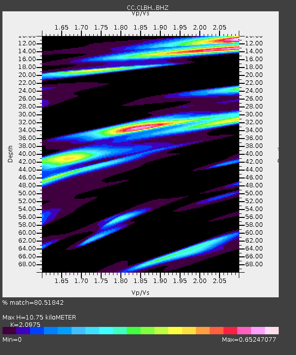
| Estimated Moho Depth: |
10.75 km |
| Estimated Crust Vp/Vs: |
2.10 |
| Assumed Crust Vp: |
6.522 km/s |
| Estimated Crust Vs: |
3.109 km/s |
| Estimated Crust Poisson's Ratio: |
0.35 |
|
| Radial Match: |
80.51842 % |
| Radial Bump: |
400 |
| Transverse Match: |
71.66338 % |
| Transverse Bump: |
400 |
| SOD ConfigId: |
13570011 |
| Insert Time: |
2019-05-02 02:13:26.681 +0000 |
| GWidth: |
2.5 |
| Max Bumps: |
400 |
| Tol: |
0.001 |
|

Signal To Noise
| Channel | StoN | STA | LTA |
| CC:CLBH: :BHZ:20181220T17:09:57.220001Z | 2.6507022 | 2.2501526E-6 | 8.488892E-7 |
| CC:CLBH: :BHN:20181220T17:09:57.220001Z | 0.67419684 | 1.2311831E-6 | 1.8261478E-6 |
| CC:CLBH: :BHE:20181220T17:09:57.220001Z | 1.7138556 | 1.975178E-6 | 1.1524763E-6 |
| Arrivals |
| Ps | 1.9 SECOND |
| PpPs | 4.8 SECOND |
| PsPs/PpSs | 6.7 SECOND |


