You are here: Home > Network List > CI - Caltech Regional Seismic Network Stations List
> Station TIN Tinemaha, Big Pine, CA, USA > Earthquake Result Viewer
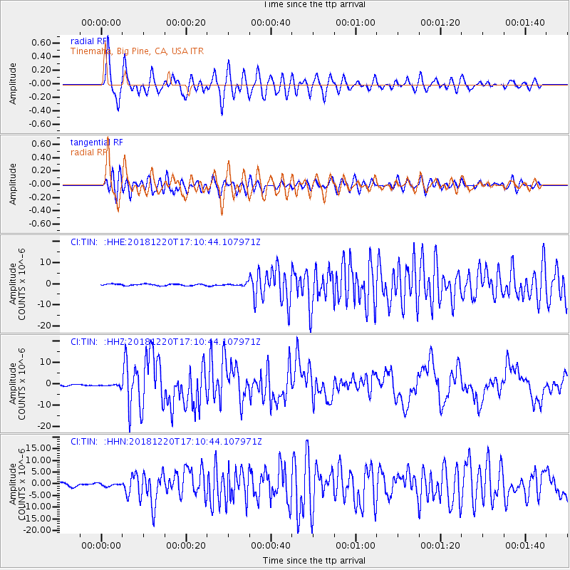
TIN Tinemaha, Big Pine, CA, USA - Earthquake Result Viewer
*The percent match for this event was below the threshold and hence no stack was calculated.
| Earthquake location: |
Komandorskiye Ostrova Region |
| Earthquake latitude/longitude: |
54.8/164.8 |
| Earthquake time(UTC): |
2018/12/20 (354) 17:01:56 GMT |
| Earthquake Depth: |
33 km |
| Earthquake Magnitude: |
7.3 Mi |
| Earthquake Catalog/Contributor: |
NEIC PDE/pt |
|
| Network: |
CI Caltech Regional Seismic Network |
| Station: |
TIN Tinemaha, Big Pine, CA, USA |
| Lat/Lon: |
37.05 N/118.23 W |
| Elevation: |
1197 m |
|
| Distance: |
53.6 deg |
| Az: |
75.639 deg |
| Baz: |
315.549 deg |
| Ray Param: |
$rayparam |
*The percent match for this event was below the threshold and hence was not used in the summary stack. |
|
| Radial Match: |
89.481476 % |
| Radial Bump: |
400 |
| Transverse Match: |
85.23277 % |
| Transverse Bump: |
400 |
| SOD ConfigId: |
13570011 |
| Insert Time: |
2019-05-02 02:14:35.270 +0000 |
| GWidth: |
2.5 |
| Max Bumps: |
400 |
| Tol: |
0.001 |
|
Signal To Noise
| Channel | StoN | STA | LTA |
| CI:TIN: :HHZ:20181220T17:10:44.107971Z | 2.193316 | 6.104837E-7 | 2.783382E-7 |
| CI:TIN: :HHN:20181220T17:10:44.107971Z | 0.9471352 | 5.991088E-7 | 6.325483E-7 |
| CI:TIN: :HHE:20181220T17:10:44.107971Z | 0.65892094 | 2.432261E-7 | 3.6912792E-7 |
| Arrivals |
| Ps | |
| PpPs | |
| PsPs/PpSs | |


