You are here: Home > Network List > G - GEOSCOPE Stations List
> Station CLF Chambon la Foret observatory, France > Earthquake Result Viewer
CLF Chambon la Foret observatory, France - Earthquake Result Viewer
| Earthquake location: |
North Of Ascension Island |
| Earthquake latitude/longitude: |
-0.0/-17.8 |
| Earthquake time(UTC): |
2016/08/29 (242) 04:29:57 GMT |
| Earthquake Depth: |
10 km |
| Earthquake Magnitude: |
7.1 MWW, 7.1 MWC, 7.4 MI |
| Earthquake Catalog/Contributor: |
NEIC PDE/NEIC COMCAT |
|
| Network: |
G GEOSCOPE |
| Station: |
CLF Chambon la Foret observatory, France |
| Lat/Lon: |
48.03 N/2.26 E |
| Elevation: |
145 m |
|
| Distance: |
51.0 deg |
| Az: |
17.269 deg |
| Baz: |
206.245 deg |
| Ray Param: |
0.06771114 |
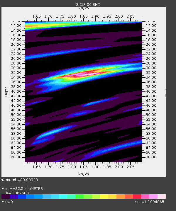
| Estimated Moho Depth: |
32.5 km |
| Estimated Crust Vp/Vs: |
1.87 |
| Assumed Crust Vp: |
6.12 km/s |
| Estimated Crust Vs: |
3.277 km/s |
| Estimated Crust Poisson's Ratio: |
0.30 |
|
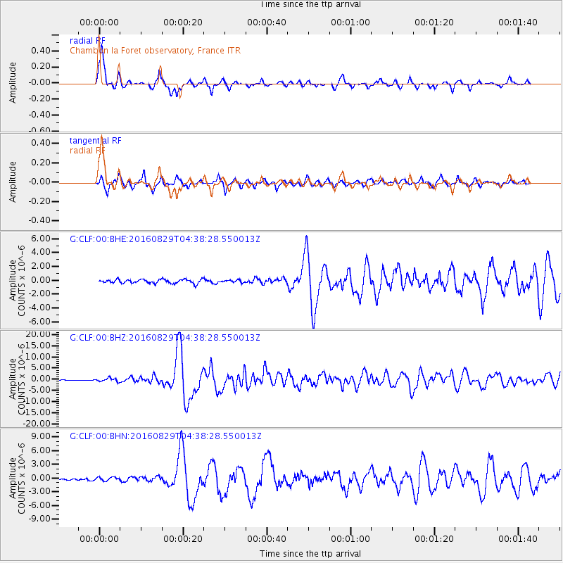
| Radial Match: |
89.98923 % |
| Radial Bump: |
363 |
| Transverse Match: |
82.32383 % |
| Transverse Bump: |
400 |
| SOD ConfigId: |
1634031 |
| Insert Time: |
2016-09-12 04:31:10.330 +0000 |
| GWidth: |
2.5 |
| Max Bumps: |
400 |
| Tol: |
0.001 |
|
Signal To Noise
| Channel | StoN | STA | LTA |
| G:CLF:00:BHZ:20160829T04:38:28.550013Z | 5.3970275 | 7.446808E-7 | 1.379798E-7 |
| G:CLF:00:BHN:20160829T04:38:28.550013Z | 1.3067907 | 3.7878607E-7 | 2.8985977E-7 |
| G:CLF:00:BHE:20160829T04:38:28.550013Z | 0.623269 | 1.7071355E-7 | 2.7390024E-7 |
| Arrivals |
| Ps | 4.8 SECOND |
| PpPs | 15 SECOND |
| PsPs/PpSs | 19 SECOND |


