You are here: Home > Network List > CN - Canadian National Seismograph Network Stations List
> Station FCC Fort Churchill, MB, CA > Earthquake Result Viewer
FCC Fort Churchill, MB, CA - Earthquake Result Viewer
| Earthquake location: |
Komandorskiye Ostrova Region |
| Earthquake latitude/longitude: |
54.8/164.8 |
| Earthquake time(UTC): |
2018/12/20 (354) 17:01:56 GMT |
| Earthquake Depth: |
33 km |
| Earthquake Magnitude: |
7.3 Mi |
| Earthquake Catalog/Contributor: |
NEIC PDE/pt |
|
| Network: |
CN Canadian National Seismograph Network |
| Station: |
FCC Fort Churchill, MB, CA |
| Lat/Lon: |
58.76 N/94.09 W |
| Elevation: |
39 m |
|
| Distance: |
50.3 deg |
| Az: |
41.635 deg |
| Baz: |
312.501 deg |
| Ray Param: |
0.06806234 |
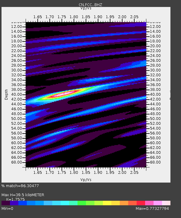
| Estimated Moho Depth: |
39.5 km |
| Estimated Crust Vp/Vs: |
1.76 |
| Assumed Crust Vp: |
6.455 km/s |
| Estimated Crust Vs: |
3.673 km/s |
| Estimated Crust Poisson's Ratio: |
0.26 |
|
| Radial Match: |
96.30477 % |
| Radial Bump: |
215 |
| Transverse Match: |
77.285194 % |
| Transverse Bump: |
400 |
| SOD ConfigId: |
13570011 |
| Insert Time: |
2019-05-02 02:15:06.793 +0000 |
| GWidth: |
2.5 |
| Max Bumps: |
400 |
| Tol: |
0.001 |
|

Signal To Noise
| Channel | StoN | STA | LTA |
| CN:FCC: :BHZ:20181220T17:10:19.024994Z | 19.871662 | 1.1932983E-5 | 6.005025E-7 |
| CN:FCC: :BHN:20181220T17:10:19.024994Z | 6.9175067 | 4.6444384E-6 | 6.7140354E-7 |
| CN:FCC: :BHE:20181220T17:10:19.024994Z | 10.704502 | 5.0005146E-6 | 4.6714126E-7 |
| Arrivals |
| Ps | 4.9 SECOND |
| PpPs | 16 SECOND |
| PsPs/PpSs | 21 SECOND |


