You are here: Home > Network List > CN - Canadian National Seismograph Network Stations List
> Station LMQ LA MALBAIE, QC > Earthquake Result Viewer
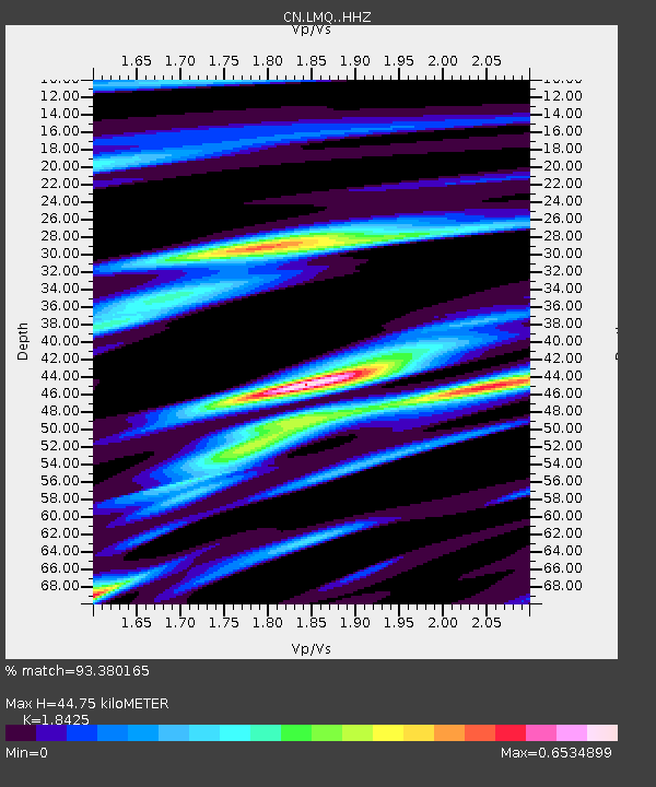
LMQ LA MALBAIE, QC - Earthquake Result Viewer
| Earthquake location: |
Komandorskiye Ostrova Region |
| Earthquake latitude/longitude: |
54.8/164.8 |
| Earthquake time(UTC): |
2018/12/20 (354) 17:01:56 GMT |
| Earthquake Depth: |
33 km |
| Earthquake Magnitude: |
7.3 Mi |
| Earthquake Catalog/Contributor: |
NEIC PDE/pt |
|
| Network: |
CN Canadian National Seismograph Network |
| Station: |
LMQ LA MALBAIE, QC |
| Lat/Lon: |
47.55 N/70.33 W |
| Elevation: |
429 m |
|
| Distance: |
67.9 deg |
| Az: |
36.873 deg |
| Baz: |
329.186 deg |
| Ray Param: |
0.05660523 |
| Estimated Moho Depth: |
44.75 km |
| Estimated Crust Vp/Vs: |
1.84 |
| Assumed Crust Vp: |
6.61 km/s |
| Estimated Crust Vs: |
3.588 km/s |
| Estimated Crust Poisson's Ratio: |
0.29 |
|
| Radial Match: |
93.380165 % |
| Radial Bump: |
400 |
| Transverse Match: |
73.82335 % |
| Transverse Bump: |
400 |
| SOD ConfigId: |
13570011 |
| Insert Time: |
2019-05-02 02:15:25.123 +0000 |
| GWidth: |
2.5 |
| Max Bumps: |
400 |
| Tol: |
0.001 |
|

Signal To Noise
| Channel | StoN | STA | LTA |
| CN:LMQ: :HHZ:20181220T17:12:20.539978Z | 6.976199 | 7.163959E-6 | 1.0269143E-6 |
| CN:LMQ: :HHN:20181220T17:12:20.539978Z | 4.0987554 | 2.2257511E-6 | 5.43031E-7 |
| CN:LMQ: :HHE:20181220T17:12:20.539978Z | 2.7761269 | 1.8974865E-6 | 6.8350136E-7 |
| Arrivals |
| Ps | 5.9 SECOND |
| PpPs | 18 SECOND |
| PsPs/PpSs | 24 SECOND |


