You are here: Home > Network List > TA - USArray Transportable Network (new EarthScope stations) Stations List
> Station K21A Alcova, Casper, WY, USA > Earthquake Result Viewer
K21A Alcova, Casper, WY, USA - Earthquake Result Viewer
| Earthquake location: |
Central Mid-Atlantic Ridge |
| Earthquake latitude/longitude: |
8.1/-38.7 |
| Earthquake time(UTC): |
2008/09/10 (254) 13:08:14 GMT |
| Earthquake Depth: |
10 km |
| Earthquake Magnitude: |
6.3 MB, 6.5 MS, 6.6 MW, 6.6 MW |
| Earthquake Catalog/Contributor: |
WHDF/NEIC |
|
| Network: |
TA USArray Transportable Network (new EarthScope stations) |
| Station: |
K21A Alcova, Casper, WY, USA |
| Lat/Lon: |
42.63 N/107.25 W |
| Elevation: |
1960 m |
|
| Distance: |
68.8 deg |
| Az: |
312.551 deg |
| Baz: |
98.72 deg |
| Ray Param: |
0.056073457 |
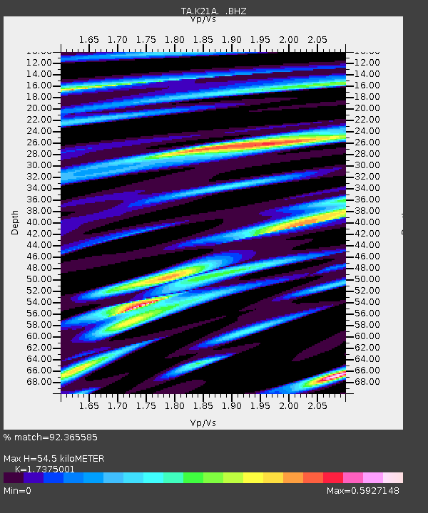
| Estimated Moho Depth: |
54.5 km |
| Estimated Crust Vp/Vs: |
1.74 |
| Assumed Crust Vp: |
6.178 km/s |
| Estimated Crust Vs: |
3.556 km/s |
| Estimated Crust Poisson's Ratio: |
0.25 |
|
| Radial Match: |
92.365585 % |
| Radial Bump: |
358 |
| Transverse Match: |
81.679665 % |
| Transverse Bump: |
400 |
| SOD ConfigId: |
2560 |
| Insert Time: |
2010-03-06 18:42:28.397 +0000 |
| GWidth: |
2.5 |
| Max Bumps: |
400 |
| Tol: |
0.001 |
|
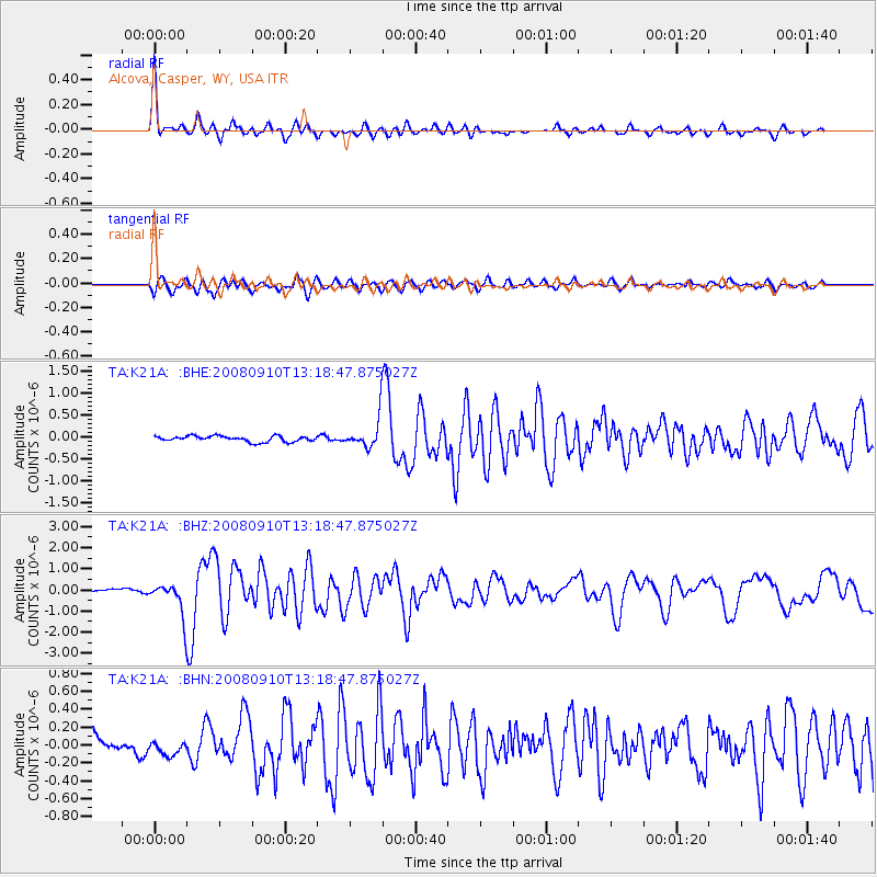
Signal To Noise
| Channel | StoN | STA | LTA |
| TA:K21A: :BHZ:20080910T13:18:47.875027Z | 7.2667522 | 7.65809E-7 | 1.0538532E-7 |
| TA:K21A: :BHN:20080910T13:18:47.875027Z | 0.9527467 | 8.840412E-8 | 9.2788696E-8 |
| TA:K21A: :BHE:20080910T13:18:47.875027Z | 5.414738 | 3.497986E-7 | 6.46012E-8 |
| Arrivals |
| Ps | 6.7 SECOND |
| PpPs | 23 SECOND |
| PsPs/PpSs | 30 SECOND |


