You are here: Home > Network List > TS - TERRAscope (Southern California Seismic Network) Stations List
> Station BAR Barrett Dam, California, USA > Earthquake Result Viewer
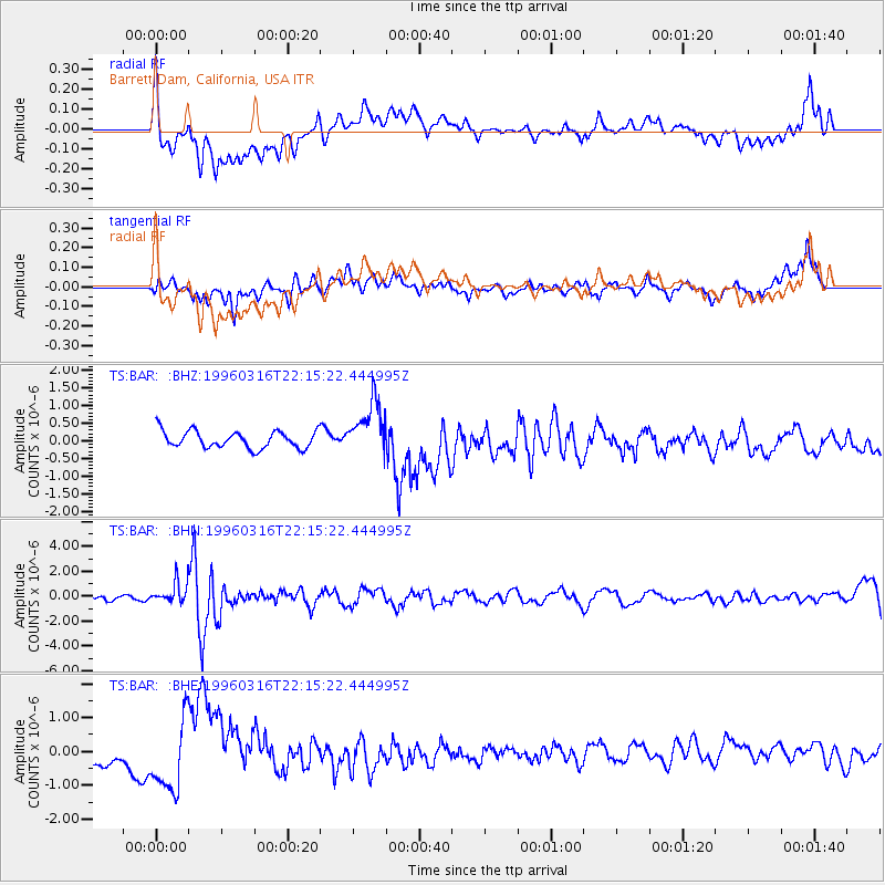
BAR Barrett Dam, California, USA - Earthquake Result Viewer
*The percent match for this event was below the threshold and hence no stack was calculated.
| Earthquake location: |
Bonin Islands, Japan Region |
| Earthquake latitude/longitude: |
29.0/138.9 |
| Earthquake time(UTC): |
1996/03/16 (076) 22:04:06 GMT |
| Earthquake Depth: |
477 km |
| Earthquake Magnitude: |
5.9 MB, 6.6 UNKNOWN, 6.1 MB |
| Earthquake Catalog/Contributor: |
WHDF/NEIC |
|
| Network: |
TS TERRAscope (Southern California Seismic Network) |
| Station: |
BAR Barrett Dam, California, USA |
| Lat/Lon: |
32.68 N/116.67 W |
| Elevation: |
548 m |
|
| Distance: |
85.7 deg |
| Az: |
55.009 deg |
| Baz: |
301.668 deg |
| Ray Param: |
$rayparam |
*The percent match for this event was below the threshold and hence was not used in the summary stack. |
|
| Radial Match: |
61.42345 % |
| Radial Bump: |
400 |
| Transverse Match: |
59.551495 % |
| Transverse Bump: |
400 |
| SOD ConfigId: |
4480 |
| Insert Time: |
2010-02-26 14:01:58.198 +0000 |
| GWidth: |
2.5 |
| Max Bumps: |
400 |
| Tol: |
0.001 |
|
Signal To Noise
| Channel | StoN | STA | LTA |
| TS:BAR: :BHN:19960316T22:15:22.444995Z | 3.711403 | 8.9495114E-7 | 2.4113555E-7 |
| TS:BAR: :BHE:19960316T22:15:22.444995Z | 4.9736695 | 1.0138831E-6 | 2.0385012E-7 |
| TS:BAR: :BHZ:19960316T22:15:22.444995Z | 3.1152842 | 7.5410617E-7 | 2.420666E-7 |
| Arrivals |
| Ps | |
| PpPs | |
| PsPs/PpSs | |


