You are here: Home > Network List > CN - Canadian National Seismograph Network Stations List
> Station ULM LAC DU BONNET, MB > Earthquake Result Viewer
ULM LAC DU BONNET, MB - Earthquake Result Viewer
| Earthquake location: |
Komandorskiye Ostrova Region |
| Earthquake latitude/longitude: |
54.8/164.8 |
| Earthquake time(UTC): |
2018/12/20 (354) 17:01:56 GMT |
| Earthquake Depth: |
33 km |
| Earthquake Magnitude: |
7.3 Mi |
| Earthquake Catalog/Contributor: |
NEIC PDE/pt |
|
| Network: |
CN Canadian National Seismograph Network |
| Station: |
ULM LAC DU BONNET, MB |
| Lat/Lon: |
50.25 N/95.88 W |
| Elevation: |
251 m |
|
| Distance: |
55.6 deg |
| Az: |
50.19 deg |
| Baz: |
316.211 deg |
| Ray Param: |
0.06465334 |
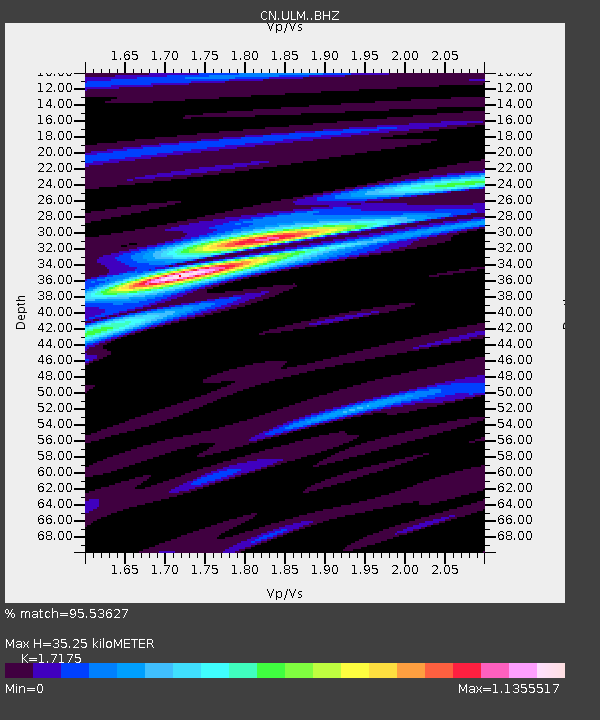
| Estimated Moho Depth: |
35.25 km |
| Estimated Crust Vp/Vs: |
1.72 |
| Assumed Crust Vp: |
6.459 km/s |
| Estimated Crust Vs: |
3.761 km/s |
| Estimated Crust Poisson's Ratio: |
0.24 |
|
| Radial Match: |
95.53627 % |
| Radial Bump: |
302 |
| Transverse Match: |
79.46991 % |
| Transverse Bump: |
400 |
| SOD ConfigId: |
13570011 |
| Insert Time: |
2019-05-02 02:15:53.170 +0000 |
| GWidth: |
2.5 |
| Max Bumps: |
400 |
| Tol: |
0.001 |
|
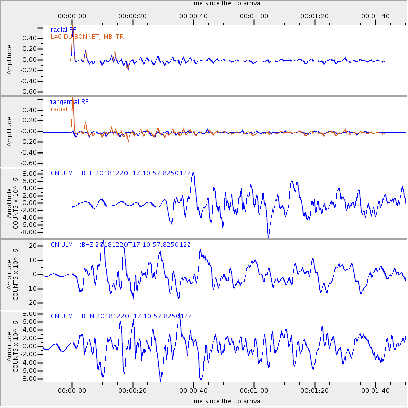
Signal To Noise
| Channel | StoN | STA | LTA |
| CN:ULM: :BHZ:20181220T17:10:57.825012Z | 11.322745 | 5.736794E-6 | 5.06661E-7 |
| CN:ULM: :BHN:20181220T17:10:57.825012Z | 4.0400476 | 1.6329681E-6 | 4.0419525E-7 |
| CN:ULM: :BHE:20181220T17:10:57.825012Z | 4.794382 | 2.420926E-6 | 5.0495055E-7 |
| Arrivals |
| Ps | 4.1 SECOND |
| PpPs | 14 SECOND |
| PsPs/PpSs | 18 SECOND |


