You are here: Home > Network List > EI - Irish National Seismic Network (INSN) Stations List
> Station VAL Valentia > Earthquake Result Viewer
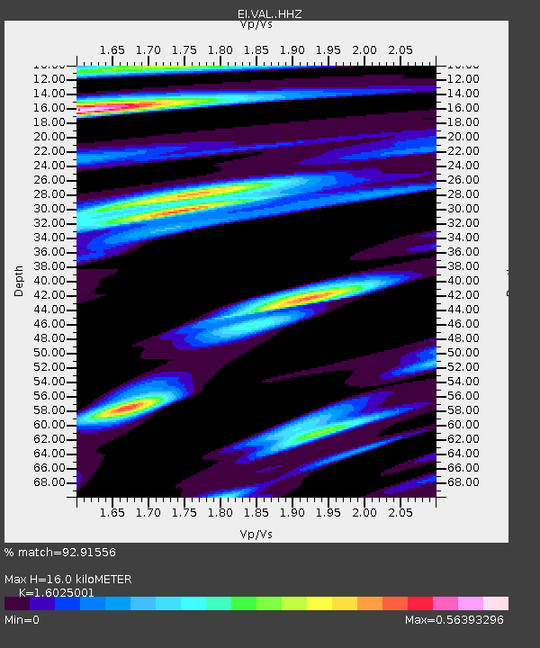
VAL Valentia - Earthquake Result Viewer
| Earthquake location: |
Komandorskiye Ostrova Region |
| Earthquake latitude/longitude: |
54.8/164.8 |
| Earthquake time(UTC): |
2018/12/20 (354) 17:01:56 GMT |
| Earthquake Depth: |
33 km |
| Earthquake Magnitude: |
7.3 Mi |
| Earthquake Catalog/Contributor: |
NEIC PDE/pt |
|
| Network: |
EI Irish National Seismic Network (INSN) |
| Station: |
VAL Valentia |
| Lat/Lon: |
51.94 N/10.24 W |
| Elevation: |
14 m |
|
| Distance: |
73.5 deg |
| Az: |
356.82 deg |
| Baz: |
2.97 deg |
| Ray Param: |
0.05291401 |
| Estimated Moho Depth: |
16.0 km |
| Estimated Crust Vp/Vs: |
1.60 |
| Assumed Crust Vp: |
6.24 km/s |
| Estimated Crust Vs: |
3.894 km/s |
| Estimated Crust Poisson's Ratio: |
0.18 |
|
| Radial Match: |
92.91556 % |
| Radial Bump: |
310 |
| Transverse Match: |
76.31276 % |
| Transverse Bump: |
400 |
| SOD ConfigId: |
13570011 |
| Insert Time: |
2019-05-02 02:16:16.556 +0000 |
| GWidth: |
2.5 |
| Max Bumps: |
400 |
| Tol: |
0.001 |
|

Signal To Noise
| Channel | StoN | STA | LTA |
| EI:VAL: :HHZ:20181220T17:12:54.049988Z | 5.042649 | 7.315227E-6 | 1.4506716E-6 |
| EI:VAL: :HHN:20181220T17:12:54.049988Z | 3.1026056 | 2.9729954E-6 | 9.582254E-7 |
| EI:VAL: :HHE:20181220T17:12:54.049988Z | 1.3596785 | 1.2113809E-6 | 8.9093186E-7 |
| Arrivals |
| Ps | 1.6 SECOND |
| PpPs | 6.4 SECOND |
| PsPs/PpSs | 8.0 SECOND |


