You are here: Home > Network List > GB - Great Britain Seismograph Network Stations List
> Station KPL PLOCKTON, SCOTLAND > Earthquake Result Viewer
KPL PLOCKTON, SCOTLAND - Earthquake Result Viewer
| Earthquake location: |
Komandorskiye Ostrova Region |
| Earthquake latitude/longitude: |
54.8/164.8 |
| Earthquake time(UTC): |
2018/12/20 (354) 17:01:56 GMT |
| Earthquake Depth: |
33 km |
| Earthquake Magnitude: |
7.3 Mi |
| Earthquake Catalog/Contributor: |
NEIC PDE/pt |
|
| Network: |
GB Great Britain Seismograph Network |
| Station: |
KPL PLOCKTON, SCOTLAND |
| Lat/Lon: |
57.34 N/5.65 W |
| Elevation: |
13 m |
|
| Distance: |
67.9 deg |
| Az: |
354.445 deg |
| Baz: |
5.926 deg |
| Ray Param: |
0.056603428 |
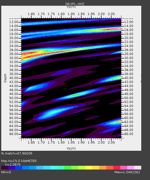
| Estimated Moho Depth: |
15.0 km |
| Estimated Crust Vp/Vs: |
2.10 |
| Assumed Crust Vp: |
6.276 km/s |
| Estimated Crust Vs: |
2.992 km/s |
| Estimated Crust Poisson's Ratio: |
0.35 |
|
| Radial Match: |
87.98009 % |
| Radial Bump: |
400 |
| Transverse Match: |
85.483444 % |
| Transverse Bump: |
400 |
| SOD ConfigId: |
13570011 |
| Insert Time: |
2019-05-02 02:16:45.848 +0000 |
| GWidth: |
2.5 |
| Max Bumps: |
400 |
| Tol: |
0.001 |
|

Signal To Noise
| Channel | StoN | STA | LTA |
| GB:KPL: :HHZ:20181220T17:12:19.929993Z | 12.714483 | 7.760719E-6 | 6.103842E-7 |
| GB:KPL: :HHN:20181220T17:12:19.929993Z | 5.5095716 | 4.114848E-6 | 7.468544E-7 |
| GB:KPL: :HHE:20181220T17:12:19.929993Z | 1.4965127 | 9.3529684E-7 | 6.249843E-7 |
| Arrivals |
| Ps | 2.7 SECOND |
| PpPs | 7.2 SECOND |
| PsPs/PpSs | 9.9 SECOND |


