You are here: Home > Network List > GO - National Seismic Network of Georgia Stations List
> Station BATM Batumi > Earthquake Result Viewer
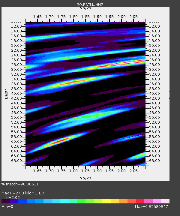
BATM Batumi - Earthquake Result Viewer
| Earthquake location: |
Komandorskiye Ostrova Region |
| Earthquake latitude/longitude: |
54.8/164.8 |
| Earthquake time(UTC): |
2018/12/20 (354) 17:01:56 GMT |
| Earthquake Depth: |
33 km |
| Earthquake Magnitude: |
7.3 Mi |
| Earthquake Catalog/Contributor: |
NEIC PDE/pt |
|
| Network: |
GO National Seismic Network of Georgia |
| Station: |
BATM Batumi |
| Lat/Lon: |
41.60 N/41.69 E |
| Elevation: |
298 m |
|
| Distance: |
72.4 deg |
| Az: |
318.784 deg |
| Baz: |
30.537 deg |
| Ray Param: |
0.053644985 |
| Estimated Moho Depth: |
27.0 km |
| Estimated Crust Vp/Vs: |
2.02 |
| Assumed Crust Vp: |
6.401 km/s |
| Estimated Crust Vs: |
3.169 km/s |
| Estimated Crust Poisson's Ratio: |
0.34 |
|
| Radial Match: |
90.30631 % |
| Radial Bump: |
400 |
| Transverse Match: |
82.09534 % |
| Transverse Bump: |
400 |
| SOD ConfigId: |
13570011 |
| Insert Time: |
2019-05-02 02:17:05.601 +0000 |
| GWidth: |
2.5 |
| Max Bumps: |
400 |
| Tol: |
0.001 |
|

Signal To Noise
| Channel | StoN | STA | LTA |
| GO:BATM: :HHZ:20181220T17:12:47.549988Z | 13.590544 | 2.648457E-6 | 1.9487499E-7 |
| GO:BATM: :HHN:20181220T17:12:47.549988Z | 1.2879568 | 1.2500759E-6 | 9.705884E-7 |
| GO:BATM: :HHE:20181220T17:12:47.549988Z | 1.4082252 | 5.7882426E-7 | 4.1103104E-7 |
| Arrivals |
| Ps | 4.4 SECOND |
| PpPs | 12 SECOND |
| PsPs/PpSs | 17 SECOND |


