You are here: Home > Network List > HL - National Observatory of Athens Digital Broadband Network Stations List
> Station ARG ARKHANGELOS, GREECE > Earthquake Result Viewer
ARG ARKHANGELOS, GREECE - Earthquake Result Viewer
| Earthquake location: |
Komandorskiye Ostrova Region |
| Earthquake latitude/longitude: |
54.8/164.8 |
| Earthquake time(UTC): |
2018/12/20 (354) 17:01:56 GMT |
| Earthquake Depth: |
33 km |
| Earthquake Magnitude: |
7.3 Mi |
| Earthquake Catalog/Contributor: |
NEIC PDE/pt |
|
| Network: |
HL National Observatory of Athens Digital Broadband Network |
| Station: |
ARG ARKHANGELOS, GREECE |
| Lat/Lon: |
36.22 N/28.13 E |
| Elevation: |
170 m |
|
| Distance: |
82.0 deg |
| Az: |
325.939 deg |
| Baz: |
23.611 deg |
| Ray Param: |
0.047161512 |
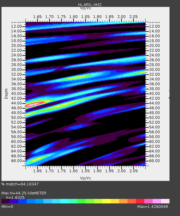
| Estimated Moho Depth: |
44.25 km |
| Estimated Crust Vp/Vs: |
1.63 |
| Assumed Crust Vp: |
6.12 km/s |
| Estimated Crust Vs: |
3.749 km/s |
| Estimated Crust Poisson's Ratio: |
0.20 |
|
| Radial Match: |
84.18347 % |
| Radial Bump: |
400 |
| Transverse Match: |
70.73138 % |
| Transverse Bump: |
400 |
| SOD ConfigId: |
13570011 |
| Insert Time: |
2019-05-02 02:17:13.081 +0000 |
| GWidth: |
2.5 |
| Max Bumps: |
400 |
| Tol: |
0.001 |
|

Signal To Noise
| Channel | StoN | STA | LTA |
| HL:ARG: :HHZ:20181220T17:13:41.340027Z | 8.005327 | 2.2739957E-6 | 2.8406032E-7 |
| HL:ARG: :HHN:20181220T17:13:41.340027Z | 2.8664541 | 9.714493E-7 | 3.3890277E-7 |
| HL:ARG: :HHE:20181220T17:13:41.340027Z | 2.4077668 | 1.007548E-6 | 4.1845746E-7 |
| Arrivals |
| Ps | 4.7 SECOND |
| PpPs | 19 SECOND |
| PsPs/PpSs | 23 SECOND |


