You are here: Home > Network List > TA - USArray Transportable Network (new EarthScope stations) Stations List
> Station K21A Alcova, Casper, WY, USA > Earthquake Result Viewer
K21A Alcova, Casper, WY, USA - Earthquake Result Viewer

| Earthquake location: |
Tonga Islands |
| Earthquake latitude/longitude: |
-16.3/-173.5 |
| Earthquake time(UTC): |
2009/10/02 (275) 01:07:39 GMT |
| Earthquake Depth: |
8.0 km |
| Earthquake Magnitude: |
6.1 MB, 6.0 MS, 6.1 MW, 6.1 MW |
| Earthquake Catalog/Contributor: |
WHDF/NEIC |
|
| Network: |
TA USArray Transportable Network (new EarthScope stations) |
| Station: |
K21A Alcova, Casper, WY, USA |
| Lat/Lon: |
42.63 N/107.25 W |
| Elevation: |
1960 m |
|
| Distance: |
84.4 deg |
| Az: |
42.728 deg |
| Baz: |
241.981 deg |
| Ray Param: |
0.045493137 |
| Estimated Moho Depth: |
47.0 km |
| Estimated Crust Vp/Vs: |
1.95 |
| Assumed Crust Vp: |
6.178 km/s |
| Estimated Crust Vs: |
3.168 km/s |
| Estimated Crust Poisson's Ratio: |
0.32 |
|
| Radial Match: |
92.44604 % |
| Radial Bump: |
351 |
| Transverse Match: |
79.54952 % |
| Transverse Bump: |
400 |
| SOD ConfigId: |
2622 |
| Insert Time: |
2010-03-06 18:43:03.055 +0000 |
| GWidth: |
2.5 |
| Max Bumps: |
400 |
| Tol: |
0.001 |
|
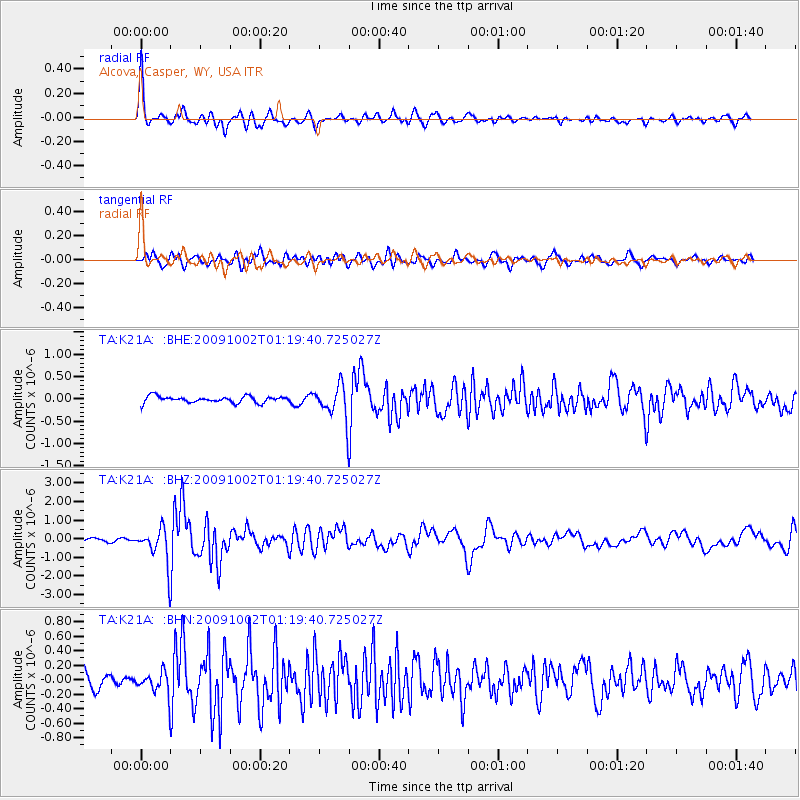
Signal To Noise
| Channel | StoN | STA | LTA |
| TA:K21A: :BHZ:20091002T01:19:40.725027Z | 7.1003585 | 9.710317E-7 | 1.3675812E-7 |
| TA:K21A: :BHN:20091002T01:19:40.725027Z | 1.6604891 | 1.5731233E-7 | 9.4738546E-8 |
| TA:K21A: :BHE:20091002T01:19:40.725027Z | 5.3525424 | 3.8391735E-7 | 7.172616E-8 |
| Arrivals |
| Ps | 7.4 SECOND |
| PpPs | 22 SECOND |
| PsPs/PpSs | 29 SECOND |


