You are here: Home > Network List > II - Global Seismograph Network (GSN - IRIS/IDA) Stations List
> Station ABPO Ambohimpanompo, Madagascar > Earthquake Result Viewer
ABPO Ambohimpanompo, Madagascar - Earthquake Result Viewer
| Earthquake location: |
North Of Ascension Island |
| Earthquake latitude/longitude: |
-0.0/-17.8 |
| Earthquake time(UTC): |
2016/08/29 (242) 04:29:57 GMT |
| Earthquake Depth: |
10 km |
| Earthquake Magnitude: |
7.1 MWW, 7.1 MWC, 7.4 MI |
| Earthquake Catalog/Contributor: |
NEIC PDE/NEIC COMCAT |
|
| Network: |
II Global Seismograph Network (GSN - IRIS/IDA) |
| Station: |
ABPO Ambohimpanompo, Madagascar |
| Lat/Lon: |
19.02 S/47.23 E |
| Elevation: |
1528 m |
|
| Distance: |
66.5 deg |
| Az: |
110.667 deg |
| Baz: |
278.519 deg |
| Ray Param: |
0.057595234 |
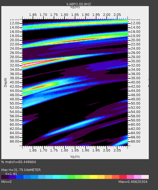
| Estimated Moho Depth: |
31.75 km |
| Estimated Crust Vp/Vs: |
1.61 |
| Assumed Crust Vp: |
6.642 km/s |
| Estimated Crust Vs: |
4.125 km/s |
| Estimated Crust Poisson's Ratio: |
0.19 |
|
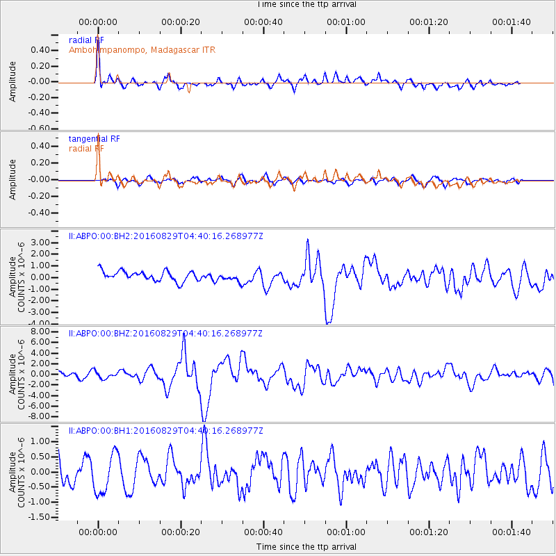
| Radial Match: |
80.449684 % |
| Radial Bump: |
400 |
| Transverse Match: |
46.13692 % |
| Transverse Bump: |
400 |
| SOD ConfigId: |
1634031 |
| Insert Time: |
2016-09-12 04:32:07.983 +0000 |
| GWidth: |
2.5 |
| Max Bumps: |
400 |
| Tol: |
0.001 |
|
Signal To Noise
| Channel | StoN | STA | LTA |
| II:ABPO:00:BHZ:20160829T04:40:16.268977Z | 1.0746919 | 6.0392665E-7 | 5.6195336E-7 |
| II:ABPO:00:BH1:20160829T04:40:16.268977Z | 1.7364178 | 6.619039E-7 | 3.8118935E-7 |
| II:ABPO:00:BH2:20160829T04:40:16.268977Z | 0.90274906 | 3.8266938E-7 | 4.2389343E-7 |
| Arrivals |
| Ps | 3.1 SECOND |
| PpPs | 12 SECOND |
| PsPs/PpSs | 15 SECOND |


