You are here: Home > Network List > II - Global Seismograph Network (GSN - IRIS/IDA) Stations List
> Station BFO Black Forest Observatory, Schiltach, Germany > Earthquake Result Viewer
BFO Black Forest Observatory, Schiltach, Germany - Earthquake Result Viewer
| Earthquake location: |
North Of Ascension Island |
| Earthquake latitude/longitude: |
-0.0/-17.8 |
| Earthquake time(UTC): |
2016/08/29 (242) 04:29:57 GMT |
| Earthquake Depth: |
10 km |
| Earthquake Magnitude: |
7.1 MWW, 7.1 MWC, 7.4 MI |
| Earthquake Catalog/Contributor: |
NEIC PDE/NEIC COMCAT |
|
| Network: |
II Global Seismograph Network (GSN - IRIS/IDA) |
| Station: |
BFO Black Forest Observatory, Schiltach, Germany |
| Lat/Lon: |
48.33 N/8.33 E |
| Elevation: |
589 m |
|
| Distance: |
53.2 deg |
| Az: |
21.542 deg |
| Baz: |
213.384 deg |
| Ray Param: |
0.066226736 |
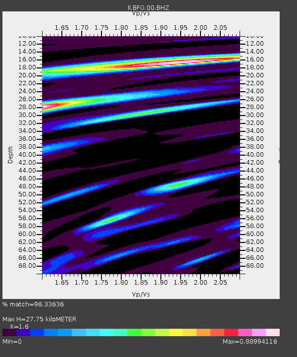
| Estimated Moho Depth: |
27.75 km |
| Estimated Crust Vp/Vs: |
1.60 |
| Assumed Crust Vp: |
6.264 km/s |
| Estimated Crust Vs: |
3.915 km/s |
| Estimated Crust Poisson's Ratio: |
0.18 |
|
| Radial Match: |
96.33636 % |
| Radial Bump: |
255 |
| Transverse Match: |
88.60717 % |
| Transverse Bump: |
400 |
| SOD ConfigId: |
1634031 |
| Insert Time: |
2016-09-12 04:32:13.996 +0000 |
| GWidth: |
2.5 |
| Max Bumps: |
400 |
| Tol: |
0.001 |
|
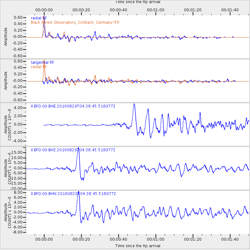
Signal To Noise
| Channel | StoN | STA | LTA |
| II:BFO:00:BHZ:20160829T04:38:45.518977Z | 6.8647833 | 5.239045E-7 | 7.6317704E-8 |
| II:BFO:00:BHN:20160829T04:38:45.518977Z | 2.8630571 | 1.6287859E-7 | 5.688975E-8 |
| II:BFO:00:BHE:20160829T04:38:45.518977Z | 1.1163311 | 8.1436646E-8 | 7.2950264E-8 |
| Arrivals |
| Ps | 2.8 SECOND |
| PpPs | 11 SECOND |
| PsPs/PpSs | 14 SECOND |


