You are here: Home > Network List > IU - Global Seismograph Network (GSN - IRIS/USGS) Stations List
> Station JOHN Johnston Island, USA > Earthquake Result Viewer
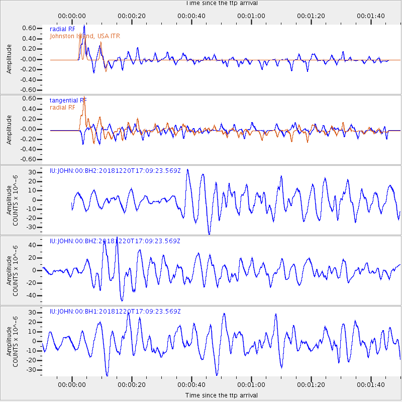
JOHN Johnston Island, USA - Earthquake Result Viewer
*The percent match for this event was below the threshold and hence no stack was calculated.
| Earthquake location: |
Komandorskiye Ostrova Region |
| Earthquake latitude/longitude: |
54.8/164.8 |
| Earthquake time(UTC): |
2018/12/20 (354) 17:01:56 GMT |
| Earthquake Depth: |
33 km |
| Earthquake Magnitude: |
7.3 Mi |
| Earthquake Catalog/Contributor: |
NEIC PDE/pt |
|
| Network: |
IU Global Seismograph Network (GSN - IRIS/USGS) |
| Station: |
JOHN Johnston Island, USA |
| Lat/Lon: |
16.73 N/169.53 W |
| Elevation: |
2.0 m |
|
| Distance: |
42.9 deg |
| Az: |
142.439 deg |
| Baz: |
338.412 deg |
| Ray Param: |
$rayparam |
*The percent match for this event was below the threshold and hence was not used in the summary stack. |
|
| Radial Match: |
73.05017 % |
| Radial Bump: |
376 |
| Transverse Match: |
62.1496 % |
| Transverse Bump: |
400 |
| SOD ConfigId: |
13570011 |
| Insert Time: |
2019-05-02 02:17:53.707 +0000 |
| GWidth: |
2.5 |
| Max Bumps: |
400 |
| Tol: |
0.001 |
|
Signal To Noise
| Channel | StoN | STA | LTA |
| IU:JOHN:00:BHZ:20181220T17:09:23.569Z | 1.2312257 | 5.791544E-6 | 4.7038848E-6 |
| IU:JOHN:00:BH1:20181220T17:09:23.569Z | 1.3679945 | 5.985989E-6 | 4.3757404E-6 |
| IU:JOHN:00:BH2:20181220T17:09:23.569Z | 0.2693693 | 1.8141943E-6 | 6.7349706E-6 |
| Arrivals |
| Ps | |
| PpPs | |
| PsPs/PpSs | |


