You are here: Home > Network List > TA - USArray Transportable Network (new EarthScope stations) Stations List
> Station K21A Alcova, Casper, WY, USA > Earthquake Result Viewer
K21A Alcova, Casper, WY, USA - Earthquake Result Viewer
| Earthquake location: |
Sea Of Okhotsk |
| Earthquake latitude/longitude: |
54.2/154.3 |
| Earthquake time(UTC): |
2008/11/24 (329) 09:02:58 GMT |
| Earthquake Depth: |
492 km |
| Earthquake Magnitude: |
6.5 MB, 7.3 MW, 7.3 MW |
| Earthquake Catalog/Contributor: |
WHDF/NEIC |
|
| Network: |
TA USArray Transportable Network (new EarthScope stations) |
| Station: |
K21A Alcova, Casper, WY, USA |
| Lat/Lon: |
42.63 N/107.25 W |
| Elevation: |
1960 m |
|
| Distance: |
61.1 deg |
| Az: |
56.456 deg |
| Baz: |
318.431 deg |
| Ray Param: |
0.059234906 |
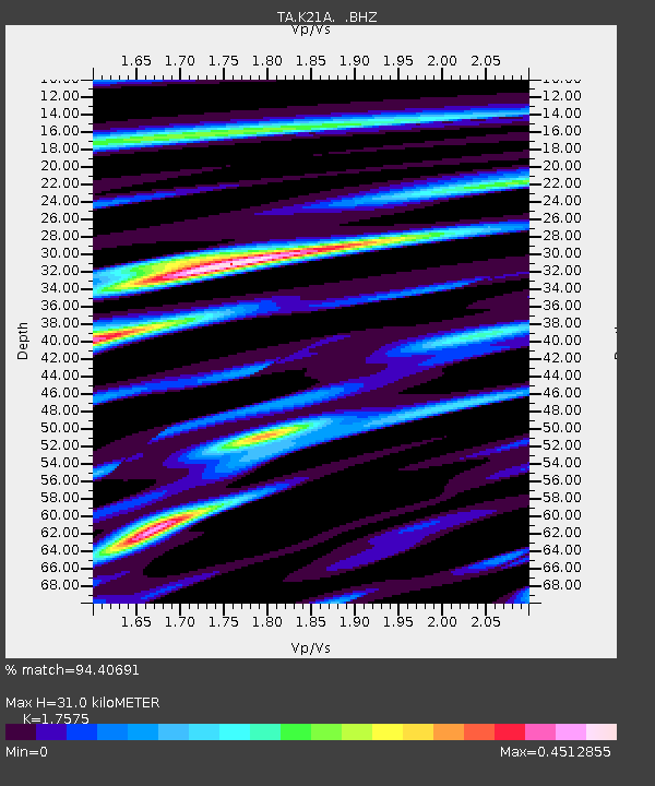
| Estimated Moho Depth: |
31.0 km |
| Estimated Crust Vp/Vs: |
1.76 |
| Assumed Crust Vp: |
6.178 km/s |
| Estimated Crust Vs: |
3.515 km/s |
| Estimated Crust Poisson's Ratio: |
0.26 |
|
| Radial Match: |
94.40691 % |
| Radial Bump: |
277 |
| Transverse Match: |
63.756752 % |
| Transverse Bump: |
400 |
| SOD ConfigId: |
2658 |
| Insert Time: |
2010-03-06 18:43:14.669 +0000 |
| GWidth: |
2.5 |
| Max Bumps: |
400 |
| Tol: |
0.001 |
|

Signal To Noise
| Channel | StoN | STA | LTA |
| TA:K21A: :BHZ:20081124T09:11:53.850027Z | 3.9070332 | 2.1889807E-6 | 5.602667E-7 |
| TA:K21A: :BHN:20081124T09:11:53.850027Z | 4.2982073 | 8.9195913E-7 | 2.0751888E-7 |
| TA:K21A: :BHE:20081124T09:11:53.850027Z | 4.089419 | 1.1422547E-6 | 2.7931958E-7 |
| Arrivals |
| Ps | 4.0 SECOND |
| PpPs | 13 SECOND |
| PsPs/PpSs | 17 SECOND |


