You are here: Home > Network List > LD - Lamont-Doherty Cooperative Seismographic Network Stations List
> Station HBVT Hinesburg, VT > Earthquake Result Viewer
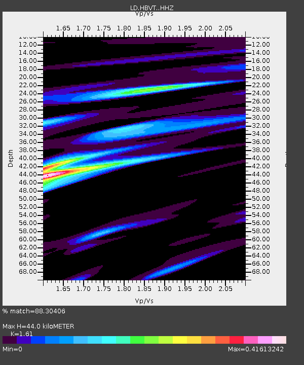
HBVT Hinesburg, VT - Earthquake Result Viewer
| Earthquake location: |
Komandorskiye Ostrova Region |
| Earthquake latitude/longitude: |
54.8/164.8 |
| Earthquake time(UTC): |
2018/12/20 (354) 17:01:56 GMT |
| Earthquake Depth: |
33 km |
| Earthquake Magnitude: |
7.3 Mi |
| Earthquake Catalog/Contributor: |
NEIC PDE/pt |
|
| Network: |
LD Lamont-Doherty Cooperative Seismographic Network |
| Station: |
HBVT Hinesburg, VT |
| Lat/Lon: |
44.36 N/73.07 W |
| Elevation: |
1130 m |
|
| Distance: |
69.6 deg |
| Az: |
40.396 deg |
| Baz: |
328.499 deg |
| Ray Param: |
0.055464238 |
| Estimated Moho Depth: |
44.0 km |
| Estimated Crust Vp/Vs: |
1.61 |
| Assumed Crust Vp: |
6.419 km/s |
| Estimated Crust Vs: |
3.987 km/s |
| Estimated Crust Poisson's Ratio: |
0.19 |
|
| Radial Match: |
88.30406 % |
| Radial Bump: |
274 |
| Transverse Match: |
60.80722 % |
| Transverse Bump: |
400 |
| SOD ConfigId: |
13570011 |
| Insert Time: |
2019-05-02 02:18:49.361 +0000 |
| GWidth: |
2.5 |
| Max Bumps: |
400 |
| Tol: |
0.001 |
|

Signal To Noise
| Channel | StoN | STA | LTA |
| LD:HBVT: :HHZ:20181220T17:12:31.440002Z | 4.4593406 | 4.7128465E-6 | 1.0568482E-6 |
| LD:HBVT: :HHN:20181220T17:12:31.440002Z | 3.7579243 | 2.0339412E-6 | 5.412406E-7 |
| LD:HBVT: :HHE:20181220T17:12:31.440002Z | 0.9179801 | 1.0159691E-6 | 1.1067442E-6 |
| Arrivals |
| Ps | 4.4 SECOND |
| PpPs | 17 SECOND |
| PsPs/PpSs | 22 SECOND |


