You are here: Home > Network List > MU - Miami University Seismic Network Stations List
> Station MUB2 Belmont > Earthquake Result Viewer
MUB2 Belmont - Earthquake Result Viewer
| Earthquake location: |
Komandorskiye Ostrova Region |
| Earthquake latitude/longitude: |
54.8/164.8 |
| Earthquake time(UTC): |
2018/12/20 (354) 17:01:56 GMT |
| Earthquake Depth: |
33 km |
| Earthquake Magnitude: |
7.3 Mi |
| Earthquake Catalog/Contributor: |
NEIC PDE/pt |
|
| Network: |
MU Miami University Seismic Network |
| Station: |
MUB2 Belmont |
| Lat/Lon: |
40.08 N/80.90 W |
| Elevation: |
384 m |
|
| Distance: |
70.1 deg |
| Az: |
48.069 deg |
| Baz: |
325.891 deg |
| Ray Param: |
0.05517532 |
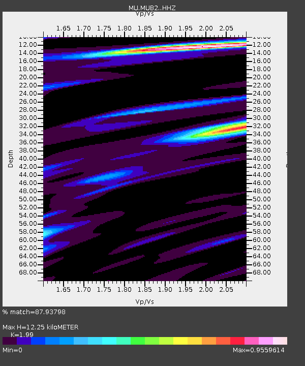
| Estimated Moho Depth: |
12.25 km |
| Estimated Crust Vp/Vs: |
1.99 |
| Assumed Crust Vp: |
6.483 km/s |
| Estimated Crust Vs: |
3.258 km/s |
| Estimated Crust Poisson's Ratio: |
0.33 |
|
| Radial Match: |
87.93798 % |
| Radial Bump: |
301 |
| Transverse Match: |
63.83071 % |
| Transverse Bump: |
400 |
| SOD ConfigId: |
13570011 |
| Insert Time: |
2019-05-02 02:19:26.581 +0000 |
| GWidth: |
2.5 |
| Max Bumps: |
400 |
| Tol: |
0.001 |
|

Signal To Noise
| Channel | StoN | STA | LTA |
| MU:MUB2: :HHZ:20181220T17:12:34.299988Z | 3.794871 | 1.5750764E-5 | 4.15054E-6 |
| MU:MUB2: :HHN:20181220T17:12:34.299988Z | 1.626273 | 5.3539884E-6 | 3.292183E-6 |
| MU:MUB2: :HHE:20181220T17:12:34.299988Z | 2.1905289 | 4.4023695E-6 | 2.0097293E-6 |
| Arrivals |
| Ps | 1.9 SECOND |
| PpPs | 5.5 SECOND |
| PsPs/PpSs | 7.4 SECOND |


