You are here: Home > Network List > N4 - Central and EAstern US Network Stations List
> Station L64A Middleborough, MA, USA > Earthquake Result Viewer
L64A Middleborough, MA, USA - Earthquake Result Viewer
| Earthquake location: |
Komandorskiye Ostrova Region |
| Earthquake latitude/longitude: |
54.8/164.8 |
| Earthquake time(UTC): |
2018/12/20 (354) 17:01:56 GMT |
| Earthquake Depth: |
33 km |
| Earthquake Magnitude: |
7.3 Mi |
| Earthquake Catalog/Contributor: |
NEIC PDE/pt |
|
| Network: |
N4 Central and EAstern US Network |
| Station: |
L64A Middleborough, MA, USA |
| Lat/Lon: |
41.94 N/70.84 W |
| Elevation: |
17 m |
|
| Distance: |
72.6 deg |
| Az: |
40.228 deg |
| Baz: |
329.961 deg |
| Ray Param: |
0.053535953 |
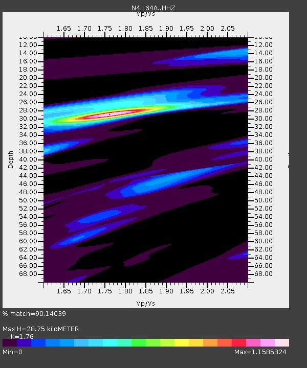
| Estimated Moho Depth: |
28.75 km |
| Estimated Crust Vp/Vs: |
1.76 |
| Assumed Crust Vp: |
6.472 km/s |
| Estimated Crust Vs: |
3.677 km/s |
| Estimated Crust Poisson's Ratio: |
0.26 |
|
| Radial Match: |
90.14039 % |
| Radial Bump: |
246 |
| Transverse Match: |
62.159836 % |
| Transverse Bump: |
400 |
| SOD ConfigId: |
13570011 |
| Insert Time: |
2019-05-02 02:20:17.986 +0000 |
| GWidth: |
2.5 |
| Max Bumps: |
400 |
| Tol: |
0.001 |
|

Signal To Noise
| Channel | StoN | STA | LTA |
| N4:L64A: :HHZ:20181220T17:12:49.099976Z | 8.959448 | 4.370958E-6 | 4.878602E-7 |
| N4:L64A: :HHN:20181220T17:12:49.099976Z | 2.7520058 | 1.8597792E-6 | 6.7579043E-7 |
| N4:L64A: :HHE:20181220T17:12:49.099976Z | 2.5766947 | 1.0731766E-6 | 4.1649346E-7 |
| Arrivals |
| Ps | 3.5 SECOND |
| PpPs | 12 SECOND |
| PsPs/PpSs | 15 SECOND |


