You are here: Home > Network List > NM - Cooperative New Madrid Seismic Network Stations List
> Station HICK Hickman,KY > Earthquake Result Viewer
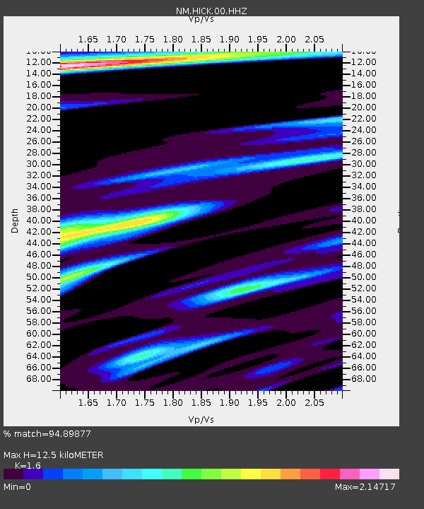
HICK Hickman,KY - Earthquake Result Viewer
| Earthquake location: |
North Of Ascension Island |
| Earthquake latitude/longitude: |
-0.0/-17.8 |
| Earthquake time(UTC): |
2016/08/29 (242) 04:29:57 GMT |
| Earthquake Depth: |
10 km |
| Earthquake Magnitude: |
7.1 MWW, 7.1 MWC, 7.4 MI |
| Earthquake Catalog/Contributor: |
NEIC PDE/NEIC COMCAT |
|
| Network: |
NM Cooperative New Madrid Seismic Network |
| Station: |
HICK Hickman,KY |
| Lat/Lon: |
36.54 N/89.23 W |
| Elevation: |
141 m |
|
| Distance: |
75.1 deg |
| Az: |
307.845 deg |
| Baz: |
101.321 deg |
| Ray Param: |
0.051863845 |
| Estimated Moho Depth: |
12.5 km |
| Estimated Crust Vp/Vs: |
1.60 |
| Assumed Crust Vp: |
6.444 km/s |
| Estimated Crust Vs: |
4.027 km/s |
| Estimated Crust Poisson's Ratio: |
0.18 |
|
| Radial Match: |
94.89877 % |
| Radial Bump: |
400 |
| Transverse Match: |
84.568375 % |
| Transverse Bump: |
400 |
| SOD ConfigId: |
1634031 |
| Insert Time: |
2016-09-12 04:33:53.713 +0000 |
| GWidth: |
2.5 |
| Max Bumps: |
400 |
| Tol: |
0.001 |
|

Signal To Noise
| Channel | StoN | STA | LTA |
| NM:HICK:00:HHZ:20160829T04:41:08.849971Z | 4.7677 | 5.049919E-7 | 1.0591939E-7 |
| NM:HICK:00:HHN:20160829T04:41:08.849971Z | 1.5098827 | 3.7455933E-7 | 2.480718E-7 |
| NM:HICK:00:HHE:20160829T04:41:08.849971Z | 1.1015102 | 2.8392918E-7 | 2.5776356E-7 |
| Arrivals |
| Ps | 1.2 SECOND |
| PpPs | 4.9 SECOND |
| PsPs/PpSs | 6.1 SECOND |


