You are here: Home > Network List > OH - Ohio Seismic Network Stations List
> Station P51A Williamsport, OH, USA > Earthquake Result Viewer
P51A Williamsport, OH, USA - Earthquake Result Viewer
| Earthquake location: |
Komandorskiye Ostrova Region |
| Earthquake latitude/longitude: |
54.8/164.8 |
| Earthquake time(UTC): |
2018/12/20 (354) 17:01:56 GMT |
| Earthquake Depth: |
33 km |
| Earthquake Magnitude: |
7.3 Mi |
| Earthquake Catalog/Contributor: |
NEIC PDE/pt |
|
| Network: |
OH Ohio Seismic Network |
| Station: |
P51A Williamsport, OH, USA |
| Lat/Lon: |
39.48 N/83.06 W |
| Elevation: |
211 m |
|
| Distance: |
69.6 deg |
| Az: |
49.893 deg |
| Baz: |
325.142 deg |
| Ray Param: |
0.055472195 |
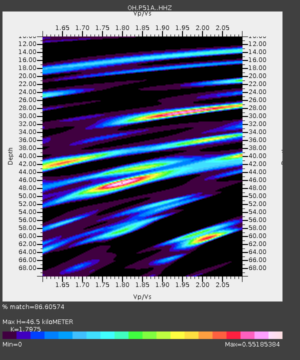
| Estimated Moho Depth: |
46.5 km |
| Estimated Crust Vp/Vs: |
1.80 |
| Assumed Crust Vp: |
6.232 km/s |
| Estimated Crust Vs: |
3.467 km/s |
| Estimated Crust Poisson's Ratio: |
0.28 |
|
| Radial Match: |
86.60574 % |
| Radial Bump: |
400 |
| Transverse Match: |
77.2239 % |
| Transverse Bump: |
400 |
| SOD ConfigId: |
13570011 |
| Insert Time: |
2019-05-02 02:22:33.066 +0000 |
| GWidth: |
2.5 |
| Max Bumps: |
400 |
| Tol: |
0.001 |
|

Signal To Noise
| Channel | StoN | STA | LTA |
| OH:P51A: :HHZ:20181220T17:12:31.599976Z | 3.75657 | 3.528258E-6 | 9.392233E-7 |
| OH:P51A: :HHN:20181220T17:12:31.599976Z | 1.3354632 | 1.2902442E-6 | 9.661399E-7 |
| OH:P51A: :HHE:20181220T17:12:31.599976Z | 2.0429716 | 1.0140774E-6 | 4.963737E-7 |
| Arrivals |
| Ps | 6.2 SECOND |
| PpPs | 20 SECOND |
| PsPs/PpSs | 26 SECOND |


