You are here: Home > Network List > PE - Penn State Network Stations List
> Station PALR Lyman Run State Park, Galeton, PA > Earthquake Result Viewer
PALR Lyman Run State Park, Galeton, PA - Earthquake Result Viewer
| Earthquake location: |
Komandorskiye Ostrova Region |
| Earthquake latitude/longitude: |
54.8/164.8 |
| Earthquake time(UTC): |
2018/12/20 (354) 17:01:56 GMT |
| Earthquake Depth: |
33 km |
| Earthquake Magnitude: |
7.3 Mi |
| Earthquake Catalog/Contributor: |
NEIC PDE/pt |
|
| Network: |
PE Penn State Network |
| Station: |
PALR Lyman Run State Park, Galeton, PA |
| Lat/Lon: |
41.73 N/77.76 W |
| Elevation: |
537 m |
|
| Distance: |
70.0 deg |
| Az: |
44.995 deg |
| Baz: |
326.89 deg |
| Ray Param: |
0.055207107 |
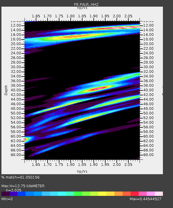
| Estimated Moho Depth: |
12.75 km |
| Estimated Crust Vp/Vs: |
2.03 |
| Assumed Crust Vp: |
6.121 km/s |
| Estimated Crust Vs: |
3.022 km/s |
| Estimated Crust Poisson's Ratio: |
0.34 |
|
| Radial Match: |
81.050156 % |
| Radial Bump: |
400 |
| Transverse Match: |
61.307453 % |
| Transverse Bump: |
400 |
| SOD ConfigId: |
13570011 |
| Insert Time: |
2019-05-02 02:23:11.199 +0000 |
| GWidth: |
2.5 |
| Max Bumps: |
400 |
| Tol: |
0.001 |
|

Signal To Noise
| Channel | StoN | STA | LTA |
| PE:PALR: :HHZ:20181220T17:12:33.934998Z | 4.531226 | 4.613628E-6 | 1.0181853E-6 |
| PE:PALR: :HHN:20181220T17:12:33.934998Z | 0.9067838 | 7.554437E-7 | 8.331023E-7 |
| PE:PALR: :HHE:20181220T17:12:33.934998Z | 4.033229 | 4.2263473E-6 | 1.0478818E-6 |
| Arrivals |
| Ps | 2.2 SECOND |
| PpPs | 6.1 SECOND |
| PsPs/PpSs | 8.3 SECOND |


