You are here: Home > Network List > PM - Portuguese National Seismic Network Stations List
> Station PFVI PM.PFVI > Earthquake Result Viewer
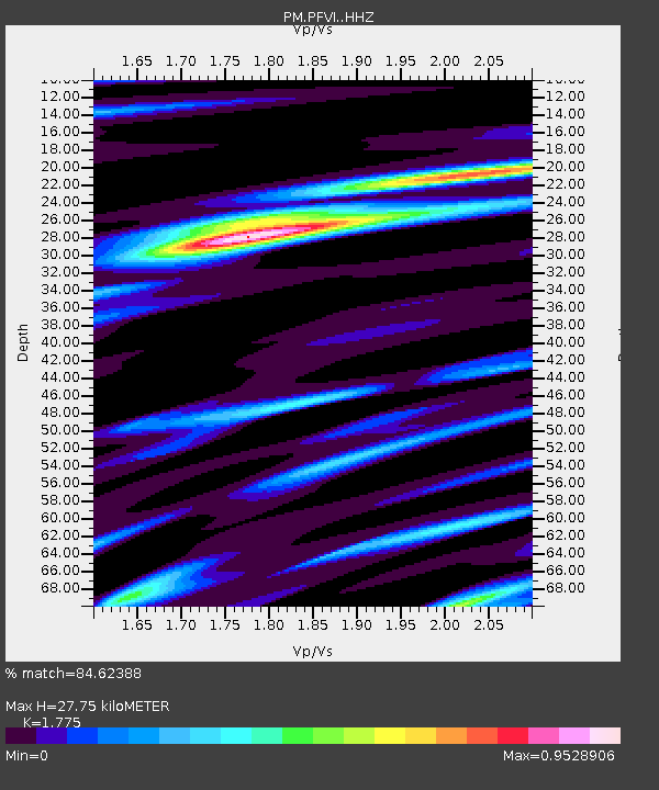
PFVI PM.PFVI - Earthquake Result Viewer
| Earthquake location: |
Komandorskiye Ostrova Region |
| Earthquake latitude/longitude: |
54.8/164.8 |
| Earthquake time(UTC): |
2018/12/20 (354) 17:01:56 GMT |
| Earthquake Depth: |
33 km |
| Earthquake Magnitude: |
7.3 Mi |
| Earthquake Catalog/Contributor: |
NEIC PDE/pt |
|
| Network: |
PM Portuguese National Seismic Network |
| Station: |
PFVI PM.PFVI |
| Lat/Lon: |
37.13 N/8.83 W |
| Elevation: |
189 m |
|
| Distance: |
88.2 deg |
| Az: |
354.93 deg |
| Baz: |
3.667 deg |
| Ray Param: |
0.04270449 |
| Estimated Moho Depth: |
27.75 km |
| Estimated Crust Vp/Vs: |
1.77 |
| Assumed Crust Vp: |
6.048 km/s |
| Estimated Crust Vs: |
3.407 km/s |
| Estimated Crust Poisson's Ratio: |
0.27 |
|
| Radial Match: |
84.62388 % |
| Radial Bump: |
400 |
| Transverse Match: |
88.52786 % |
| Transverse Bump: |
343 |
| SOD ConfigId: |
13570011 |
| Insert Time: |
2019-05-02 02:23:29.993 +0000 |
| GWidth: |
2.5 |
| Max Bumps: |
400 |
| Tol: |
0.001 |
|

Signal To Noise
| Channel | StoN | STA | LTA |
| PM:PFVI: :HHZ:20181220T17:14:12.580017Z | 8.557525 | 3.3461401E-6 | 3.910173E-7 |
| PM:PFVI: :HHN:20181220T17:14:12.580017Z | 1.7732688 | 1.4132963E-6 | 7.970006E-7 |
| PM:PFVI: :HHE:20181220T17:14:12.580017Z | 0.72742033 | 3.3214135E-7 | 4.5660173E-7 |
| Arrivals |
| Ps | 3.6 SECOND |
| PpPs | 12 SECOND |
| PsPs/PpSs | 16 SECOND |


