You are here: Home > Network List > TA - USArray Transportable Network (new EarthScope stations) Stations List
> Station K21A Alcova, Casper, WY, USA > Earthquake Result Viewer
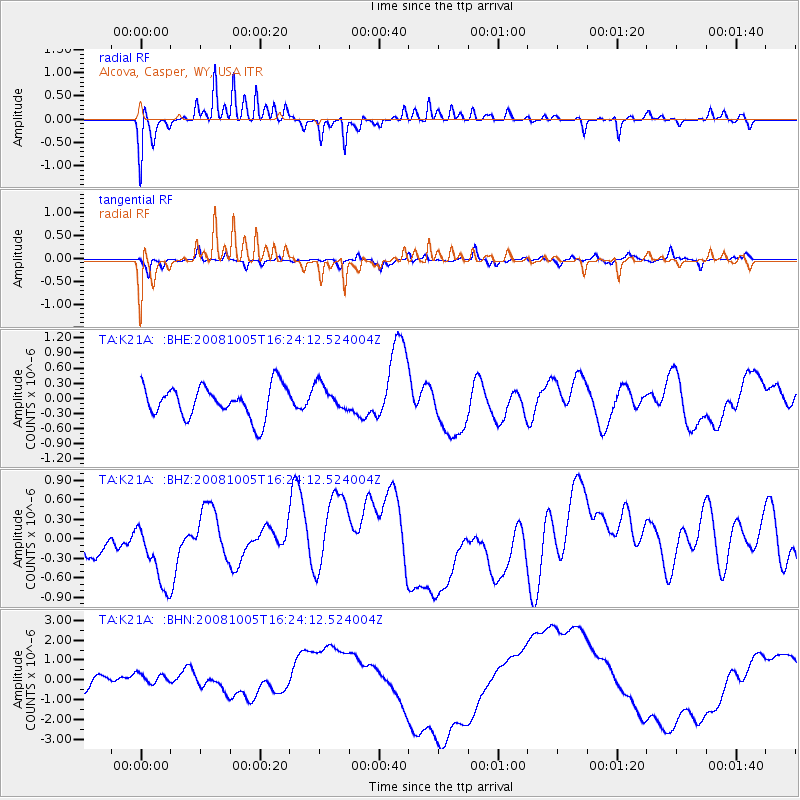
K21A Alcova, Casper, WY, USA - Earthquake Result Viewer
*The percent match for this event was below the threshold and hence no stack was calculated.
| Earthquake location: |
Tajikistan-Xinjiang Border Reg. |
| Earthquake latitude/longitude: |
39.5/73.9 |
| Earthquake time(UTC): |
2008/10/05 (279) 16:11:10 GMT |
| Earthquake Depth: |
35 km |
| Earthquake Magnitude: |
5.6 MB |
| Earthquake Catalog/Contributor: |
WHDF/NEIC |
|
| Network: |
TA USArray Transportable Network (new EarthScope stations) |
| Station: |
K21A Alcova, Casper, WY, USA |
| Lat/Lon: |
42.63 N/107.25 W |
| Elevation: |
1960 m |
|
| Distance: |
98.2 deg |
| Az: |
0.849 deg |
| Baz: |
359.11 deg |
| Ray Param: |
$rayparam |
*The percent match for this event was below the threshold and hence was not used in the summary stack. |
|
| Radial Match: |
67.516045 % |
| Radial Bump: |
323 |
| Transverse Match: |
59.56541 % |
| Transverse Bump: |
320 |
| SOD ConfigId: |
2556 |
| Insert Time: |
2010-03-06 18:44:32.336 +0000 |
| GWidth: |
2.5 |
| Max Bumps: |
400 |
| Tol: |
0.001 |
|
Signal To Noise
| Channel | StoN | STA | LTA |
| TA:K21A: :BHZ:20081005T16:24:12.524004Z | 1.6508539 | 5.3767735E-7 | 3.256965E-7 |
| TA:K21A: :BHN:20081005T16:24:12.524004Z | 1.1752571 | 3.7197293E-7 | 3.1650345E-7 |
| TA:K21A: :BHE:20081005T16:24:12.524004Z | 0.830617 | 2.6083873E-7 | 3.140301E-7 |
| Arrivals |
| Ps | |
| PpPs | |
| PsPs/PpSs | |


