You are here: Home > Network List > RV - Regional Alberta Seismic Observatory for Earthquake Studies Network Stations List
> Station DEDWA Deadwood Lookout Tower, AB > Earthquake Result Viewer
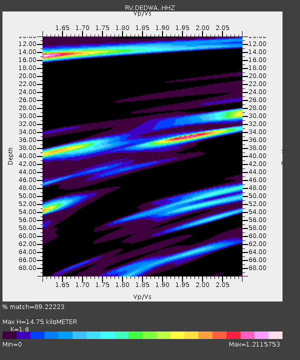
DEDWA Deadwood Lookout Tower, AB - Earthquake Result Viewer
| Earthquake location: |
Komandorskiye Ostrova Region |
| Earthquake latitude/longitude: |
54.8/164.8 |
| Earthquake time(UTC): |
2018/12/20 (354) 17:01:56 GMT |
| Earthquake Depth: |
33 km |
| Earthquake Magnitude: |
7.3 Mi |
| Earthquake Catalog/Contributor: |
NEIC PDE/pt |
|
| Network: |
RV Regional Alberta Seismic Observatory for Earthquake Studies Network |
| Station: |
DEDWA Deadwood Lookout Tower, AB |
| Lat/Lon: |
56.64 N/117.39 W |
| Elevation: |
652 m |
|
| Distance: |
41.6 deg |
| Az: |
54.387 deg |
| Baz: |
301.668 deg |
| Ray Param: |
0.07361327 |
| Estimated Moho Depth: |
14.75 km |
| Estimated Crust Vp/Vs: |
1.60 |
| Assumed Crust Vp: |
6.444 km/s |
| Estimated Crust Vs: |
4.027 km/s |
| Estimated Crust Poisson's Ratio: |
0.18 |
|
| Radial Match: |
89.22223 % |
| Radial Bump: |
348 |
| Transverse Match: |
67.05332 % |
| Transverse Bump: |
396 |
| SOD ConfigId: |
13570011 |
| Insert Time: |
2019-05-02 02:24:10.776 +0000 |
| GWidth: |
2.5 |
| Max Bumps: |
400 |
| Tol: |
0.001 |
|

Signal To Noise
| Channel | StoN | STA | LTA |
| RV:DEDWA: :HHZ:20181220T17:09:10.720001Z | 8.340577 | 8.299754E-6 | 9.951054E-7 |
| RV:DEDWA: :HHN:20181220T17:09:10.720001Z | 1.4122268 | 2.047511E-6 | 1.4498457E-6 |
| RV:DEDWA: :HHE:20181220T17:09:10.720001Z | 2.3319032 | 3.5610046E-6 | 1.5270807E-6 |
| Arrivals |
| Ps | 1.5 SECOND |
| PpPs | 5.5 SECOND |
| PsPs/PpSs | 7.0 SECOND |


