You are here: Home > Network List > TA - USArray Transportable Network (new EarthScope stations) Stations List
> Station H31M Peel River, Yukon, CAN > Earthquake Result Viewer
H31M Peel River, Yukon, CAN - Earthquake Result Viewer
| Earthquake location: |
Komandorskiye Ostrova Region |
| Earthquake latitude/longitude: |
54.8/164.8 |
| Earthquake time(UTC): |
2018/12/20 (354) 17:01:56 GMT |
| Earthquake Depth: |
33 km |
| Earthquake Magnitude: |
7.3 Mi |
| Earthquake Catalog/Contributor: |
NEIC PDE/pt |
|
| Network: |
TA USArray Transportable Network (new EarthScope stations) |
| Station: |
H31M Peel River, Yukon, CAN |
| Lat/Lon: |
65.81 N/134.34 W |
| Elevation: |
642 m |
|
| Distance: |
30.7 deg |
| Az: |
44.748 deg |
| Baz: |
278.936 deg |
| Ray Param: |
0.07922113 |
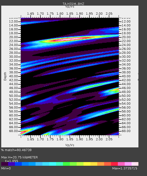
| Estimated Moho Depth: |
20.75 km |
| Estimated Crust Vp/Vs: |
1.86 |
| Assumed Crust Vp: |
6.419 km/s |
| Estimated Crust Vs: |
3.461 km/s |
| Estimated Crust Poisson's Ratio: |
0.30 |
|
| Radial Match: |
90.46739 % |
| Radial Bump: |
400 |
| Transverse Match: |
75.84101 % |
| Transverse Bump: |
400 |
| SOD ConfigId: |
13570011 |
| Insert Time: |
2019-05-02 02:24:54.889 +0000 |
| GWidth: |
2.5 |
| Max Bumps: |
400 |
| Tol: |
0.001 |
|
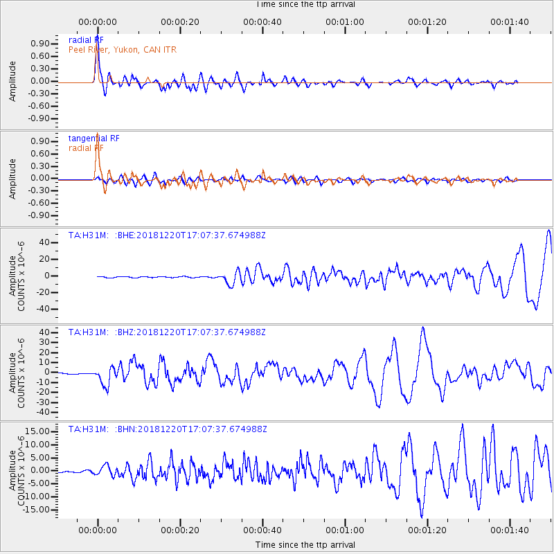
Signal To Noise
| Channel | StoN | STA | LTA |
| TA:H31M: :BHZ:20181220T17:07:37.674988Z | 31.374378 | 8.998545E-6 | 2.868119E-7 |
| TA:H31M: :BHN:20181220T17:07:37.674988Z | 5.4801483 | 1.9062138E-6 | 3.4783983E-7 |
| TA:H31M: :BHE:20181220T17:07:37.674988Z | 12.048283 | 7.709876E-6 | 6.399149E-7 |
| Arrivals |
| Ps | 3.0 SECOND |
| PpPs | 8.5 SECOND |
| PsPs/PpSs | 12 SECOND |


